|
|
|
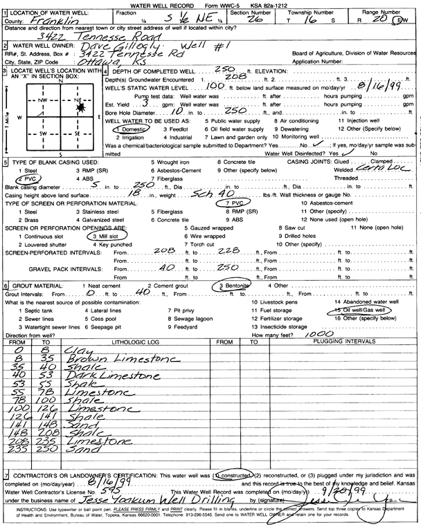
Specific Water Well Detail |
|
|
| Location Info | |||
| Owner: Gillogly, Dave | Status: Constructed | ||
| Location: T16S, R20E, Sec. 26, S2 NE | County: Franklin | ||
| Directions: 3422 Tennesse Rd, Ottawa | |||
| Latitude: 38.6321103 | Longitude: -95.1603018 | Datum NAD 27 | |
| Latitude: 38.6321214 | Longitude: -95.1605505 | Datum NAD 83 | |
| Longitude and latitude calculated by Survey from township-range-section-quarter calls. Only good to within the quarter call accuracy. | |||
| View well on interactive map | |||
| General Info | ||
| Well Depth: 250 ft. | Elevation: ft. | |
| Static Water Level: 100 ft. | Est. Yield: 3 gpm. | |
| Comp. Date: 16-Aug-1999 | Well Use: Domestic | |
| DWR Applic. #: | Other ID: | |
| Driller Info | ||
| Driller: Jesse Yoakum Well Drilling | License #: 595 | |
| Scanned Form | View scan |
|
Chemical Sample Submitted?:
Water Well disinfected?: | ||
| Casing Info | ||
| Casing Type:
Casing Joints: |
Diam: in. to ft | |
| Casing height above land surface: in
Casing Weight: lbs/ft Wall thickness or gauge no.: | ||
| Screen and Perforation Info | ||
| Screen Type: | Screen Openings: | |
| Screen-perforated intervals | From: ft to ft | |
| Gravel pack intervals | From: ft to ft | |
| Grout Info | ||
| Grout used: | From: to ft | |
| Source of Possible Contamination | ||
| Source: | ||
| Direction from well: | Distance: ft | |
| Lithologic Log
(Log data entered by KGS.) | ||
| From: 0 ft. to 8 ft. | Clay | |
| From: 8 ft. to 35 ft. | Limestone, brown | |
| From: 35 ft. to 40 ft. | Shale | |
| From: 40 ft. to 53 ft. | Limestone, dark | |
| From: 53 ft. to 55 ft. | Shale | |
| From: 55 ft. to 78 ft. | Limestone | |
| From: 78 ft. to 100 ft. | Shale | |
| From: 100 ft. to 126 ft. | Limestone | |
| From: 126 ft. to 141 ft. | Shale | |
| From: 141 ft. to 148 ft. | Sand | |
| From: 148 ft. to 208 ft. | Shale | |
| From: 208 ft. to 235 ft. | Limestone | |
| From: 235 ft. to 250 ft. | Sand | |