|
|
|
Specific Water Well Detail |
|
|
| Location Info | |||
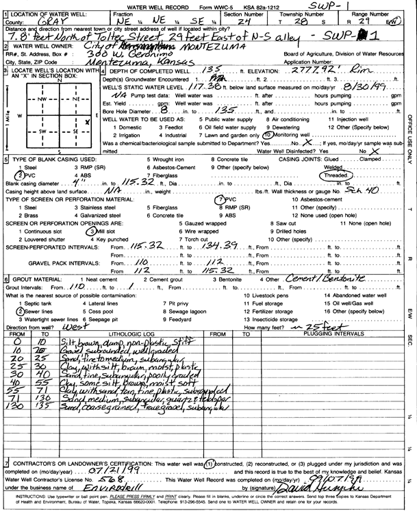
| Owner: City of Montezuma | Status: Constructed | ||
| Location: T28S, R29W, Sec. 24, NE NE SE | County: Gray | ||
| Directions: 7.8' N of Toltec st, 29' E of N-S alley | |||
| Latitude: 37.5976886 | Longitude: -100.4344109 | Datum NAD 27 | |
| Latitude: 37.5977116 | Longitude: -100.4348375 | Datum NAD 83 | |
| Longitude and latitude calculated by Survey from township-range-section-quarter calls. Only good to within the quarter call accuracy. | |||
| View well on interactive map | |||
| General Info | ||
| Well Depth: 135 ft. | Elevation: 2777.92 ft. | |
| Static Water Level: 117.38 ft. | Est. Yield: gpm. | |
| Comp. Date: 21-Jul-1999 | Well Use: Monitoring well/observation/piezometer | |
| DWR Applic. #: | Other ID: SWP 1 | |
| Driller Info | ||
| Driller: Envirodrill | License #: 568 | |
| Scanned Form | View scan |
|
Chemical Sample Submitted?:
Water Well disinfected?: | ||
| Casing Info | ||
| Casing Type:
Casing Joints: |
Diam: in. to ft | |
| Casing height above land surface: in
Casing Weight: lbs/ft Wall thickness or gauge no.: | ||
| Screen and Perforation Info | ||
| Screen Type: | Screen Openings: | |
| Screen-perforated intervals | From: ft to ft | |
| Gravel pack intervals | From: ft to ft | |
| Grout Info | ||
| Grout used: | From: to ft | |
| Source of Possible Contamination | ||
| Source: | ||
| Direction from well: | Distance: ft | |
| Lithologic Log
(Log data entered by KGS.) | ||
| From: 0 ft. to 10 ft. | Silt, brown, damp, non-plastic, stiff | |
| From: 10 ft. to 20 ft. | Gravel, subrounded, well graded | |
| From: 20 ft. to 25 ft. | Sand, fine to medium, subangular | |
| From: 25 ft. to 30 ft. | Clay, with silt, brown, moist, plastic | |
| From: 30 ft. to 40 ft. | Sand, fine, subangular, poorly graded | |
| From: 40 ft. to 55 ft. | Clay, some silt, brown, moist, soft | |
| From: 55 ft. to 71 ft. | Clay, with sand, tan, fine, plastic, subgraded | |
| From: 71 ft. to 130 ft. | Sand, medium, subangular, quartz and feldspar | |
| From: 130 ft. to 135 ft. | Sand, coarse grained, trace gravel, subangular | |