|
|
|
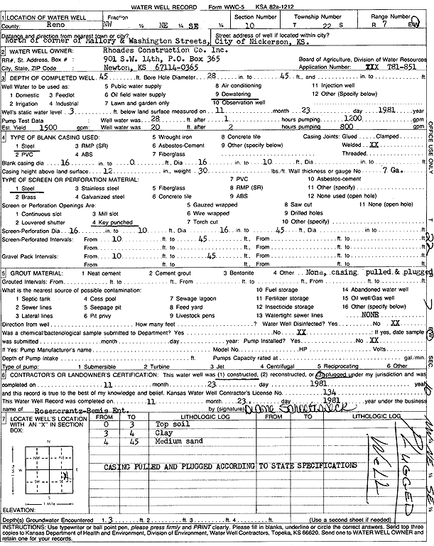
Specific Water Well Detail |
|
|
| Location Info | |||
| Owner: Rhoades Construction Co., Inc. | Status: Plugged | ||
| Location: T22S, R7W, Sec. 10, NW NE SE | County: Reno | ||
| Directions: N of Mallory and Washington St | |||
| Latitude: 38.1510639 | Longitude: -98.0720358 | Datum NAD 27 | |
| Latitude: 38.1510749 | Longitude: -98.0723699 | Datum NAD 83 | |
| Longitude and latitude calculated by Survey from township-range-section-quarter calls. Only good to within the quarter call accuracy. | |||
| View well on interactive map | |||
| General Info | ||
| Well Depth: 45 ft. | Elevation: ft. | |
| Static Water Level: 3 ft. | Est. Yield: gpm. | |
| Comp. Date: 23-Nov-1981 | Well Use: Dewatering | |
| DWR Applic. #: T81-851 | Other ID: | |
| Driller Info | ||
| Driller: Rosencrantz-Bemis Enterprises, Inc. | License #: 134 | |
| Scanned Form | View scan |
| Casing Info | ||
|
Casing Type:
Diam: in. Casing height above land surface: in | ||
| Grout Info | ||
| Grout used: | From: to ft | |
| Source of Possible Contamination | ||
| Source: | ||
| Direction from well: | Distance: ft | |