|
|
|
Specific Water Well Detail |
|
|
| Location Info | |||
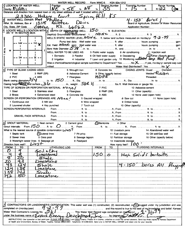
| Owner: Findley, Pat | Status: Constructed | ||
| Location: T15S, R22E, Sec. 35, NE NW SE NE | County: Miami | ||
| Directions: 23306 Hickory Court, Spring Hill (four 150-foot bores) | |||
| Latitude: 38.7054201 | Longitude: -94.9293007 | Datum NAD 27 | |
| Latitude: 38.705432 | Longitude: -94.929545 | Datum NAD 83 | |
| Longitude and latitude from GPS measurements. | |||
| GPS Latitude: 38.705432 | GPS Longitude: -94.929545 | Datum NAD83 | |
| View well on interactive map | |||
| General Info | ||
| Well Depth: 150 ft. | Elevation: ft. | |
| Static Water Level: ft. | Est. Yield: gpm. | |
| Comp. Date: 02-Sep-1999 | Well Use: Heat Pump (Closed Loop/Disposal), Geothermal | |
| DWR Applic. #: | Other ID: | |
| Driller Info | ||
| Driller: Evans Energy Development, Inc. | License #: 561 | |
| Scanned Form | View scan |
|
Chemical Sample Submitted?:
Water Well disinfected?: | ||
| Casing Info | ||
| Casing Type:
Casing Joints: |
Diam: in. to ft | |
| Casing height above land surface: in
Casing Weight: lbs/ft Wall thickness or gauge no.: | ||
| Screen and Perforation Info | ||
| Screen Type: | Screen Openings: | |
| Screen-perforated intervals | From: ft to ft | |
| Gravel pack intervals | From: ft to ft | |
| Grout Info | ||
| Grout used: | From: to ft | |
| Source of Possible Contamination | ||
| Source: | ||
| Direction from well: | Distance: ft | |
| Lithologic Log
(Log data entered by KGS.) | ||
| From: 0 ft. to 4 ft. | soil and clay | |
| From: 4 ft. to 8 ft. | limestone | |
| From: 8 ft. to 20 ft. | shale | |
| From: 20 ft. to 43 ft. | limestone | |
| From: 43 ft. to 124 ft. | shale | |
| From: 124 ft. to 138 ft. | limestone | |
| From: 138 ft. to 142 ft. | shale | |
| From: 142 ft. to 150 ft. | limestone | |