|
|
|
Specific Water Well Detail |
|
|
| Location Info | |||
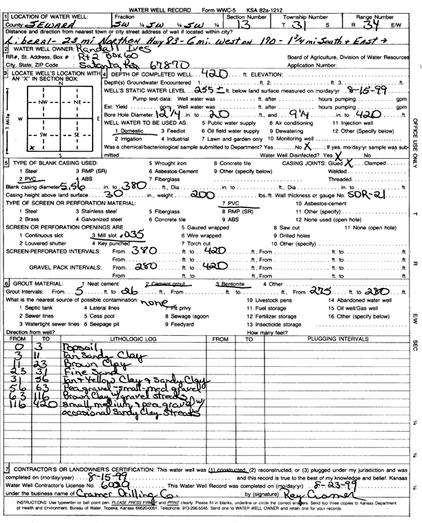
| Owner: Ives, Randall | Status: Constructed | ||
| Location: T31S, R34W, Sec. 13, SW SW SW | County: Seward | ||
| Directions: from Liberal: 23 mi N on Hwy 83, 6 mi W on 190, 1.75 mi S, E into site | |||
| Latitude: 37.3449552 | Longitude: -100.9761208 | Datum NAD 27 | |
| Latitude: 37.3449793 | Longitude: -100.976564 | Datum NAD 83 | |
| Longitude and latitude calculated by Survey from township-range-section-quarter calls. Only good to within the quarter call accuracy. | |||
| View well on interactive map | |||
| General Info | ||
| Well Depth: 420 ft. | Elevation: ft. | |
| Static Water Level: 255 ft. | Est. Yield: gpm. | |
| Comp. Date: 15-Aug-1999 | Well Use: Domestic | |
| DWR Applic. #: | Other ID: | |
| Driller Info | ||
| Driller: Cramer Drilling Co. | License #: 600 | |
| Scanned Form | View scan |
|
Chemical Sample Submitted?:
Water Well disinfected?: | ||
| Casing Info | ||
| Casing Type:
Casing Joints: |
Diam: in. to ft | |
| Casing height above land surface: in
Casing Weight: lbs/ft Wall thickness or gauge no.: | ||
| Screen and Perforation Info | ||
| Screen Type: | Screen Openings: | |
| Screen-perforated intervals | From: ft to ft | |
| Gravel pack intervals | From: ft to ft | |
| Grout Info | ||
| Grout used: | From: to ft | |
| Source of Possible Contamination | ||
| Source: | ||
| Direction from well: | Distance: ft | |
| Lithologic Log
(Log data entered by KGS.) | ||
| From: 0 ft. to 3 ft. | topsoil | |
| From: 3 ft. to 11 ft. | tan sandy clay | |
| From: 11 ft. to 23 ft. | brown clay | |
| From: 23 ft. to 31 ft. | fine sand | |
| From: 31 ft. to 56 ft. | tan and yellow clay and sandy clay | |
| From: 56 ft. to 63 ft. | pea gravel - small-med gravel | |
| From: 63 ft. to 116 ft. | brown clay with gravel streaks | |
| From: 116 ft. to 420 ft. | small, medium and pea gravel with occasional sandy clay streaks | |