|
|
|
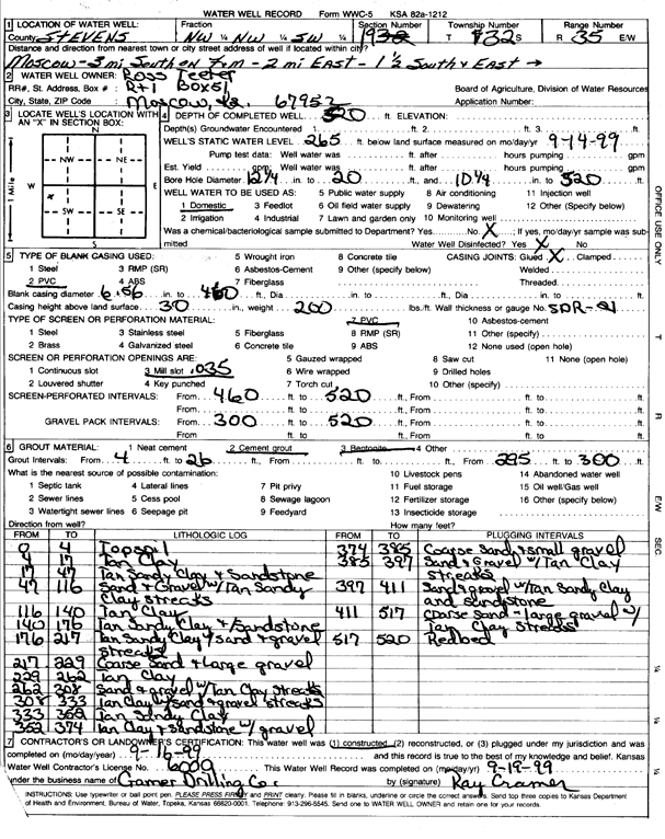
Specific Water Well Detail |
|
|
| Location Info | |||
| Owner: Teeter, Ross | Status: Constructed | ||
| Location: T32S, R35W, Sec. 19, NW NW SW | County: Stevens | ||
| Directions: from Moscow, 3 mi S on F and M, 2 mi E, 1.5 mi S, and E into site | |||
| Latitude: 37.2487593 | Longitude: -101.1746307 | Datum NAD 27 | |
| Latitude: 37.2487832 | Longitude: -101.1750674 | Datum NAD 83 | |
| Longitude and latitude calculated by Survey from township-range-section-quarter calls. Only good to within the quarter call accuracy. | |||
| View well on interactive map | |||
| General Info | ||
| Well Depth: 520 ft. | Elevation: ft. | |
| Static Water Level: 265 ft. | Est. Yield: gpm. | |
| Comp. Date: 16-Sep-1999 | Well Use: Domestic | |
| DWR Applic. #: | Other ID: | |
| Driller Info | ||
| Driller: Ray Cramer Drilling Co. | License #: 600 | |
| Scanned Form | View scan |
|
Chemical Sample Submitted?:
Water Well disinfected?: | ||
| Casing Info | ||
| Casing Type:
Casing Joints: |
Diam: in. to ft | |
| Casing height above land surface: in
Casing Weight: lbs/ft Wall thickness or gauge no.: | ||
| Screen and Perforation Info | ||
| Screen Type: | Screen Openings: | |
| Screen-perforated intervals | From: ft to ft | |
| Gravel pack intervals | From: ft to ft | |
| Grout Info | ||
| Grout used: | From: to ft | |
| Source of Possible Contamination | ||
| Source: | ||
| Direction from well: | Distance: ft | |
| Lithologic Log
(Log data entered by KGS.) | ||
| From: 0 ft. to 4 ft. | topsoil | |
| From: 4 ft. to 17 ft. | tan clay | |
| From: 17 ft. to 47 ft. | tan sandy clay and sandstone | |
| From: 47 ft. to 116 ft. | sand and gravel with tan sandy clay streaks | |
| From: 116 ft. to 140 ft. | tan clay | |
| From: 140 ft. to 176 ft. | tan sandy clay and sandstone | |
| From: 176 ft. to 217 ft. | tan sandy clay with sand and gravel streaks | |
| From: 217 ft. to 229 ft. | coarse sand and large gravel | |
| From: 229 ft. to 262 ft. | tan clay | |
| From: 262 ft. to 308 ft. | sand and gravel with tan clay streaks | |
| From: 308 ft. to 333 ft. | tan clay with sand and gravel streaks | |
| From: 333 ft. to 352 ft. | tan sandy clay | |
| From: 352 ft. to 374 ft. | tan clay and sandstone with gravel | |
| From: 374 ft. to 385 ft. | coarse sand and small gravel | |
| From: 385 ft. to 397 ft. | sand and gravel with tan clay streaks | |
| From: 397 ft. to 411 ft. | sand and gravel with tan sandy clay and sandstone | |
| From: 411 ft. to 517 ft. | coarse sand - large gravel with tan clay streaks | |
| From: 517 ft. to 520 ft. | red bed | |