|
|
|
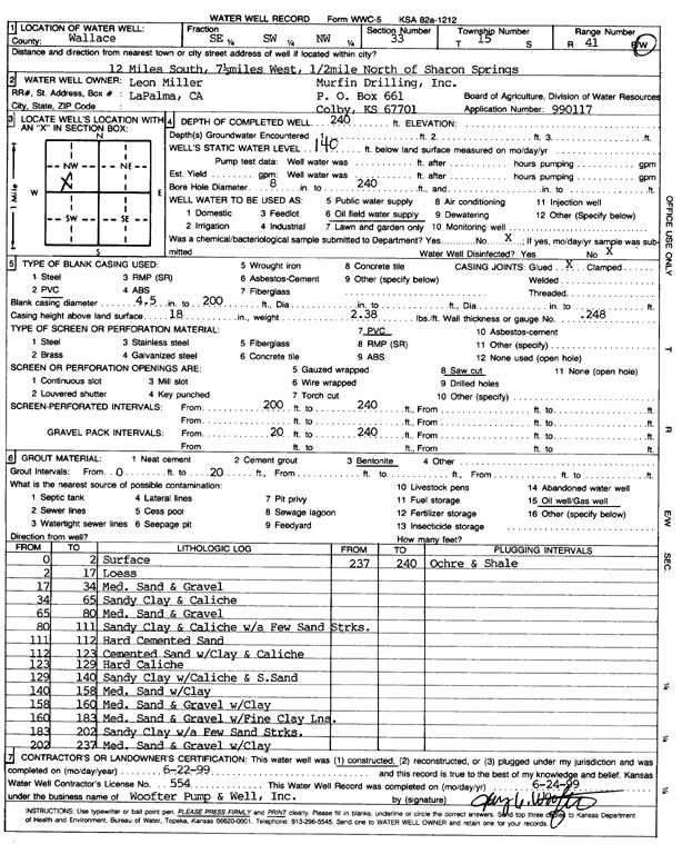
Specific Water Well Detail |
|
|
| Location Info | |||
| Owner: Murfin Drilling/Leon Miller | Status: Constructed | ||
| Location: T15S, R41W, Sec. 33, SE SW NW | County: Wallace | ||
| Directions: 12 mi S, 7.5 mi W, .5 mi N of Sharon Springs | |||
| Latitude: 38.7060058 | Longitude: -101.8876564 | Datum NAD 27 | |
| Latitude: 38.7060176 | Longitude: -101.888109 | Datum NAD 83 | |
| Longitude and latitude calculated by Survey from township-range-section-quarter calls. Only good to within the quarter call accuracy. | |||
| View well on interactive map | |||
| General Info | ||
| Well Depth: 240 ft. | Elevation: ft. | |
| Static Water Level: 140 ft. | Est. Yield: gpm. | |
| Comp. Date: 22-Jun-1999 | Well Use: Oil Field Water Supply | |
| DWR Applic. #: 990117 | Other ID: | |
| Links | |
| No Wizard information available. | |
| View info from WIMAS Water Right Data base... | |
| Driller Info | ||
| Driller: Woofter Pump & Well, Inc. | License #: 554 | |
| Scanned Form | View scan |
|
Chemical Sample Submitted?:
Water Well disinfected?: | ||
| Casing Info | ||
| Casing Type:
Casing Joints: |
Diam: in. to ft | |
| Casing height above land surface: in
Casing Weight: lbs/ft Wall thickness or gauge no.: | ||
| Screen and Perforation Info | ||
| Screen Type: | Screen Openings: | |
| Screen-perforated intervals | From: ft to ft | |
| Gravel pack intervals | From: ft to ft | |
| Grout Info | ||
| Grout used: | From: to ft | |
| Source of Possible Contamination | ||
| Source: | ||
| Direction from well: | Distance: ft | |
| Lithologic Log
(Log data entered by KGS.) | ||
| From: 0 ft. to 2 ft. | Surface | |
| From: 2 ft. to 17 ft. | Loess | |
| From: 17 ft. to 34 ft. | Medium sand and gravel | |
| From: 34 ft. to 65 ft. | Sandy clay and caliche | |
| From: 65 ft. to 80 ft. | Medium sand and gravel | |
| From: 80 ft. to 111 ft. | Sandy clay and caliche with a few sand streaks | |
| From: 111 ft. to 112 ft. | Hard cemented sand | |
| From: 112 ft. to 123 ft. | Cemented sand with clay and caliche | |
| From: 123 ft. to 129 ft. | Hard caliche | |
| From: 129 ft. to 140 ft. | Sandy clay with caliche and some sand | |
| From: 140 ft. to 158 ft. | Medium sand with clay | |
| From: 158 ft. to 160 ft. | Medium sand and gravel with clay | |
| From: 160 ft. to 183 ft. | Medium sand and gravel with fine clay lens | |
| From: 183 ft. to 202 ft. | Sandy clay with a few sand streaks | |
| From: 202 ft. to 237 ft. | Medium sand and gravel with clay | |
| From: 237 ft. to 240 ft. | Ochre and shale | |