|
|
|
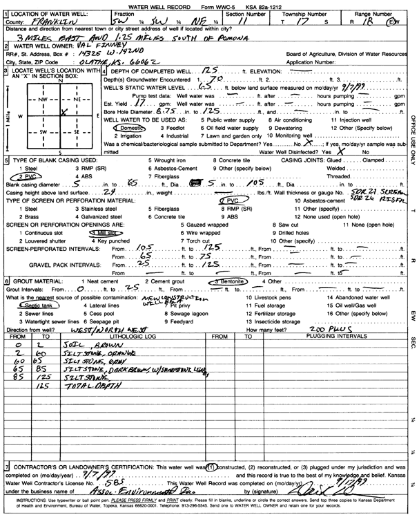
Specific Water Well Detail |
|
|
| Location Info | |||
| Owner: Finney, Val | Status: Constructed | ||
| Location: T17S, R18E, Sec. 11, SW SW NE | County: Franklin | ||
| Directions: From Pomona, 3 mi E, 1.25 mi S | |||
| Latitude: 38.587417 | Longitude: -95.3864402 | Datum NAD 27 | |
| Latitude: 38.5874284 | Longitude: -95.3866953 | Datum NAD 83 | |
| Longitude and latitude calculated by Survey from township-range-section-quarter calls. Only good to within the quarter call accuracy. | |||
| View well on interactive map | |||
| General Info | ||
| Well Depth: 125 ft. | Elevation: ft. | |
| Static Water Level: 65 ft. | Est. Yield: 17 gpm. | |
| Comp. Date: 07-Sep-1999 | Well Use: Domestic | |
| DWR Applic. #: | Other ID: | |
| Driller Info | ||
| Driller: Associated Environmental, Inc. | License #: 585 | |
| Scanned Form | View scan |
|
Chemical Sample Submitted?:
Water Well disinfected?: | ||
| Casing Info | ||
| Casing Type:
Casing Joints: |
Diam: in. to ft | |
| Casing height above land surface: in
Casing Weight: lbs/ft Wall thickness or gauge no.: | ||
| Screen and Perforation Info | ||
| Screen Type: | Screen Openings: | |
| Screen-perforated intervals | From: ft to ft | |
| Gravel pack intervals | From: ft to ft | |
| Grout Info | ||
| Grout used: | From: to ft | |
| Source of Possible Contamination | ||
| Source: | ||
| Direction from well: | Distance: ft | |
| Lithologic Log
(Log data entered by KGS.) | ||
| From: 0 ft. to 2 ft. | Soil, brown | |
| From: 2 ft. to 60 ft. | Siltstone, orange | |
| From: 60 ft. to 65 ft. | Siltstone, gray | |
| From: 65 ft. to 85 ft. | Siltstone, dark brown, with sandstone lenses | |
| From: 85 ft. to 125 ft. | Siltstone | |