|
|
|
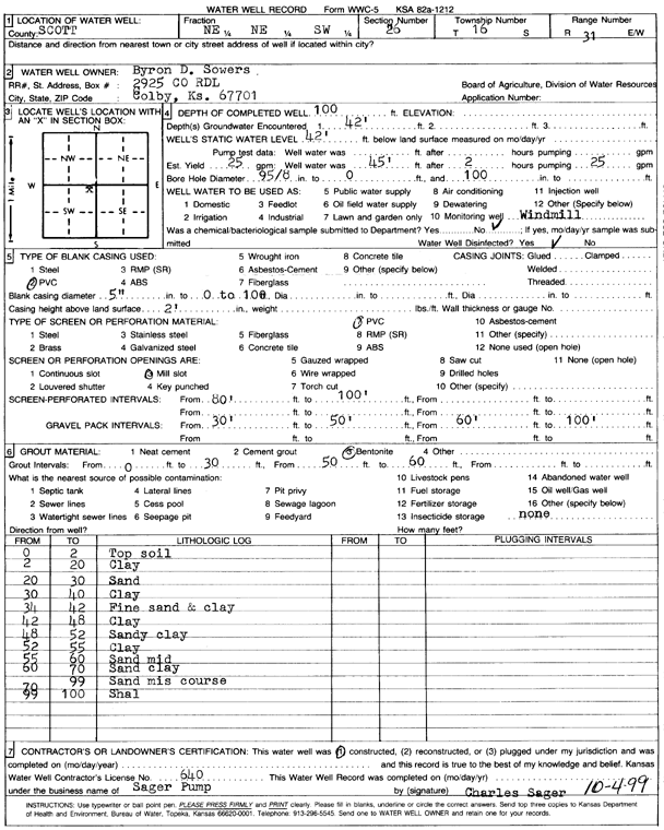
Specific Water Well Detail |
|
|
| Location Info | |||
| Owner: Sowers, Byron D. | Status: Constructed | ||
| Location: T16S, R31W, Sec. 26, NE NE SW | County: Scott | ||
| Directions: | |||
| Latitude: 38.634386 | Longitude: -100.7160984 | Datum NAD 27 | |
| Latitude: 38.6344016 | Longitude: -100.7165206 | Datum NAD 83 | |
| Longitude and latitude calculated by Survey from township-range-section-quarter calls. Only good to within the quarter call accuracy. | |||
| View well on interactive map | |||
| General Info | ||
| Well Depth: 100 ft. | Elevation: ft. | |
| Static Water Level: 42 ft. | Est. Yield: 25 gpm. | |
| Comp. Date: 04-Oct-1999 | Well Use: Domestic, Livestock | |
| DWR Applic. #: | Other ID: | |
| Driller Info | ||
| Driller: Sager's Pump Service | License #: 640 | |
| Scanned Form | View scan |
|
Chemical Sample Submitted?:
Water Well disinfected?: | ||
| Casing Info | ||
| Casing Type:
Casing Joints: |
Diam: in. to ft | |
| Casing height above land surface: in
Casing Weight: lbs/ft Wall thickness or gauge no.: | ||
| Screen and Perforation Info | ||
| Screen Type: | Screen Openings: | |
| Screen-perforated intervals | From: ft to ft | |
| Gravel pack intervals | From: ft to ft | |
| Grout Info | ||
| Grout used: | From: to ft | |
| Source of Possible Contamination | ||
| Source: | ||
| Direction from well: | Distance: ft | |
| Lithologic Log
(Log data entered by KGS.) | ||
| From: 0 ft. to 2 ft. | top soil | |
| From: 2 ft. to 20 ft. | clay | |
| From: 20 ft. to 30 ft. | sand | |
| From: 30 ft. to 40 ft. | clay | |
| From: 40 ft. to 42 ft. | fine sand and clay | |
| From: 42 ft. to 48 ft. | clay | |
| From: 48 ft. to 52 ft. | sandy clay | |
| From: 52 ft. to 55 ft. | clay | |
| From: 55 ft. to 60 ft. | sand mid | |
| From: 60 ft. to 70 ft. | sand clay | |
| From: 70 ft. to 99 ft. | sand mis coarse | |
| From: 99 ft. to 100 ft. | shale | |