|
|
|
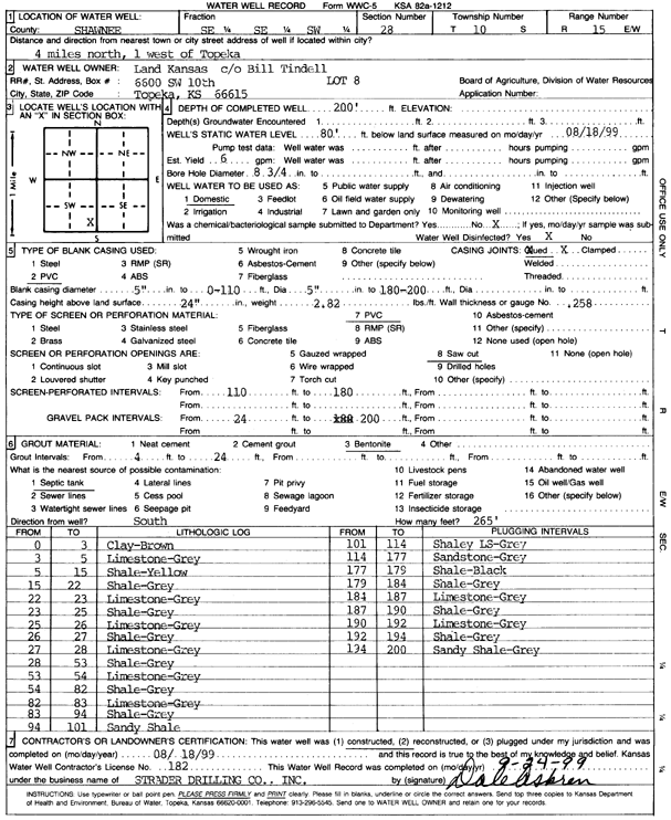
Specific Water Well Detail |
|
|
| Location Info | |||
| Owner: Land Kansas | Status: Constructed | ||
| Location: T10S, R15E, Sec. 28, SE SE SW | County: Shawnee | ||
| Directions: from Topeka: 4 mi N, 1 mi W | |||
| Latitude: 39.1448683 | Longitude: -95.7482847 | Datum NAD 27 | |
| Latitude: 39.144867 | Longitude: -95.748546 | Datum NAD 83 | |
| Longitude and latitude calculated by Survey from township-range-section-quarter calls. Only good to within the quarter call accuracy. | |||
| View well on interactive map | |||
| General Info | ||
| Well Depth: 200 ft. | Elevation: ft. | |
| Static Water Level: 80 ft. | Est. Yield: 6 gpm. | |
| Comp. Date: 18-Aug-1999 | Well Use: Domestic | |
| DWR Applic. #: | Other ID: | |
| Driller Info | ||
| Driller: Strader Drilling Co., Inc. | License #: 182 | |
| Scanned Form | View scan |
|
Chemical Sample Submitted?:
Water Well disinfected?: | ||
| Casing Info | ||
| Casing Type:
Casing Joints: |
Diam: in. to ft | |
| Casing height above land surface: in
Casing Weight: lbs/ft Wall thickness or gauge no.: | ||
| Screen and Perforation Info | ||
| Screen Type: | Screen Openings: | |
| Screen-perforated intervals | From: ft to ft | |
| Gravel pack intervals | From: ft to ft | |
| Grout Info | ||
| Grout used: | From: to ft | |
| Source of Possible Contamination | ||
| Source: | ||
| Direction from well: | Distance: ft | |
| Lithologic Log
(Log data entered by KGS.) | ||
| From: 0 ft. to 3 ft. | clay, brown | |
| From: 3 ft. to 5 ft. | limestone, gray | |
| From: 5 ft. to 15 ft. | shale, yellow | |
| From: 15 ft. to 22 ft. | shale, gray | |
| From: 22 ft. to 23 ft. | limestone, gray | |
| From: 23 ft. to 25 ft. | shale, gray | |
| From: 25 ft. to 26 ft. | limestone, gray | |
| From: 26 ft. to 27 ft. | shale, gray | |
| From: 27 ft. to 28 ft. | limestone, gray | |
| From: 28 ft. to 53 ft. | shale, gray | |
| From: 53 ft. to 54 ft. | limestone, gray | |
| From: 54 ft. to 82 ft. | shale, gray | |
| From: 82 ft. to 83 ft. | limestone, gray | |
| From: 83 ft. to 94 ft. | shale, gray | |
| From: 94 ft. to 101 ft. | sandy shale | |
| From: 101 ft. to 114 ft. | shaley limestone, gray | |
| From: 114 ft. to 177 ft. | sandstone, gray | |
| From: 177 ft. to 179 ft. | shale, black | |
| From: 179 ft. to 184 ft. | shale, gray | |
| From: 184 ft. to 187 ft. | limestone, gray | |
| From: 187 ft. to 190 ft. | shale, gray | |
| From: 190 ft. to 192 ft. | limestone, gray | |
| From: 192 ft. to 194 ft. | shale, gray | |
| From: 194 ft. to 200 ft. | sandy shale, gray | |