|
|
|
Specific Water Well Detail |
|
|
| Location Info | |||
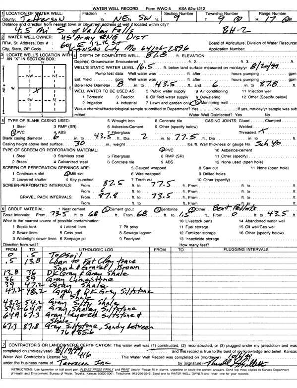
| Owner: U.S. Army Corps of Engineers | Status: Constructed | ||
| Location: T9S, R17E, Sec. 9, NE SW | County: Jefferson | ||
| Directions: from Valley Falls: 4.5 mi S | |||
| Latitude: 39.279712 | Longitude: -95.5280889 | Datum NAD 27 | |
| Latitude: 39.27971 | Longitude: -95.5283432 | Datum NAD 83 | |
| Longitude and latitude calculated by Survey from township-range-section-quarter calls. Only good to within the quarter call accuracy. | |||
| View well on interactive map | |||
| General Info | ||
| Well Depth: 87.8 ft. | Elevation: ft. | |
| Static Water Level: 16.5 ft. | Est. Yield: gpm. | |
| Comp. Date: 19-Aug-1999 | Well Use: Monitoring well/observation/piezometer | |
| DWR Applic. #: | Other ID: BH 2 | |
| Driller Info | ||
| Driller: Terracon, Inc. | License #: 416 | |
| Scanned Form | View scan |
|
Chemical Sample Submitted?:
Water Well disinfected?: | ||
| Casing Info | ||
| Casing Type:
Casing Joints: |
Diam: in. to ft | |
| Casing height above land surface: in
Casing Weight: lbs/ft Wall thickness or gauge no.: | ||
| Screen and Perforation Info | ||
| Screen Type: | Screen Openings: | |
| Screen-perforated intervals | From: ft to ft | |
| Gravel pack intervals | From: ft to ft | |
| Grout Info | ||
| Grout used: | From: to ft | |
| Source of Possible Contamination | ||
| Source: | ||
| Direction from well: | Distance: ft | |
| Lithologic Log
(Log data entered by KGS.) | ||
| From: 0 ft. to .5 ft. | top soil | |
| From: .5 ft. to 13.8 ft. | lean to fat clay with trace sand and gravel, brown | |
| From: 13.8 ft. to 36 ft. | dark gray and gray shale | |
| From: 36 ft. to 39 ft. | gray limestone | |
| From: 39 ft. to 47.2 ft. | gray shale | |
| From: 47.2 ft. to 48.2 ft. | gray and dark gray siltstone and shale | |
| From: 48.2 ft. to 54.2 ft. | gray silty shale | |
| From: 54.2 ft. to 64.9 ft. | gray shaley siltstone | |
| From: 64.9 ft. to 67.3 ft. | gray layers siltstone and shale | |
| From: 67.3 ft. to 87.8 ft. | gray siltstone, sandy between 76 and 85.6 feet | |