|
|
|
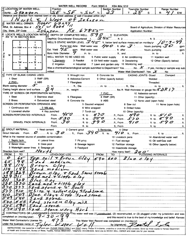
Specific Water Well Detail |
|
|
| Location Info | |||
| Owner: Canny, Roger | Status: Constructed | ||
| Location: T28S, R41W, Sec. 23, SE SE SW | County: Stanton | ||
| Directions: from Johnson, 1 mi N and 1 mi W | |||
| Latitude: 37.5929618 | Longitude: -101.7716545 | Datum NAD 27 | |
| Latitude: 37.592978 | Longitude: -101.7721043 | Datum NAD 83 | |
| Longitude and latitude calculated by Survey from township-range-section-quarter calls. Only good to within the quarter call accuracy. | |||
| View well on interactive map | |||
| General Info | ||
| Well Depth: 590 ft. | Elevation: ft. | |
| Static Water Level: 345 ft. | Est. Yield: 45 gpm. | |
| Comp. Date: 30-Sep-1999 | Well Use: Domestic | |
| DWR Applic. #: | Other ID: | |
| Driller Info | ||
| Driller: Tyler Water Well, Inc. | License #: 473 | |
| Scanned Form | View scan |
|
Chemical Sample Submitted?:
Water Well disinfected?: | ||
| Casing Info | ||
| Casing Type:
Casing Joints: |
Diam: in. to ft | |
| Casing height above land surface: in
Casing Weight: lbs/ft Wall thickness or gauge no.: | ||
| Screen and Perforation Info | ||
| Screen Type: | Screen Openings: | |
| Screen-perforated intervals | From: ft to ft | |
| Gravel pack intervals | From: ft to ft | |
| Grout Info | ||
| Grout used: | From: to ft | |
| Source of Possible Contamination | ||
| Source: | ||
| Direction from well: | Distance: ft | |
| Lithologic Log
(Log data entered by KGS.) | ||
| From: 0 ft. to 65 ft. | top soil and brown clay | |
| From: 65 ft. to 98 ft. | sand medium | |
| From: 98 ft. to 114 ft. | brown clay | |
| From: 114 ft. to 188 ft. | sand medium | |
| From: 188 ft. to 229 ft. | brown clay and sandstone streaks | |
| From: 229 ft. to 311 ft. | sand medium and little clay | |
| From: 311 ft. to 328 ft. | blue clay | |
| From: 328 ft. to 370 ft. | sand med and little clay | |
| From: 370 ft. to 377 ft. | sandstone and 4 feet rock | |
| From: 377 ft. to 410 ft. | white and yellow clay and sandstone | |
| From: 410 ft. to 509 ft. | blue clay and little sandstone | |
| From: 509 ft. to 540 ft. | sandstone | |
| From: 540 ft. to 555 ft. | sandstone and clay mix | |
| From: 555 ft. to 570 ft. | sandstone and clay mix | |
| From: 570 ft. to 590 ft. | sandstone very hard | |
| From: 590 ft. to 600 ft. | blue clay | |