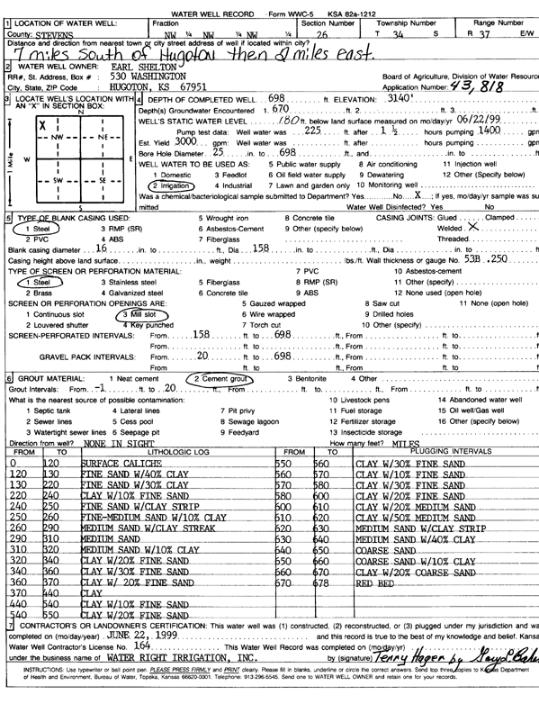
KGS Home Page Water Well Data base Specific Water Well Detail
Water Resources

Well T34S, R37W, Sec. 26, NW NW NW, Action: Constructed

Location Info
Owner: Shelton, Earl Status: Constructed
Location: T34S, R37W, Sec. 26, NW NW NW County: Stevens
Directions: from Hugoton, 7 mi S and 2 mi E
Latitude: 37.0675362 Longitude: -101.3189509 Datum NAD 27
Latitude: 37.0675621 Longitude: -101.319389 Datum NAD 83
Longitude and latitude calculated by Survey from township-range-section-quarter calls. Only good to within the quarter call accuracy.
View well on interactive map
General Info
Well Depth: 698 ft. Elevation: ft.
Static Water Level: 180 ft. Est. Yield: 3000 gpm.
Comp. Date: 22-Jun-1999 Well Use: Irrigation
DWR Applic. #: 43818 Other ID:
Links
No Wizard information available.
View info from WIMAS Water Right Data base...
Driller Info
Driller: Water Right Irrigation, Inc. License #:
Scanned Form
View form(s) on screen Download scan(s)
The download files contain one or more TIFF images compressed into a ZIP archive. Your browser may be already set up to decompress these files. The TIFFs are 300 dpi archival-quality scans of the WWC5 forms and can be viewed by software like Adobe PhotoShop.
Chemical Sample Submitted?:
Water Well disinfected?:
Casing Info
Casing Type:
Casing Joints:
Diam: in. to ft
Casing height above land surface: in
Casing Weight: lbs/ft
Wall thickness or gauge no.:
Screen and Perforation Info
Screen Type: Screen Openings:
Screen-perforated intervals From: ft to ft
Gravel pack intervals From: ft to ft
Grout Info
Grout used: From: to ft
Source of Possible Contamination
Source:
Direction from well: Distance: ft
Lithologic Log
(Log data entered by KGS.)
From: 0 ft. to 120 ft. surface caliche
From: 120 ft. to 130 ft. fine sand with 40% clay
From: 130 ft. to 220 ft. fine sand with 30% clay
From: 220 ft. to 240 ft. clay with 10% fine sand
From: 240 ft. to 250 ft. fine sand with clay strip
From: 250 ft. to 260 ft. fine-medium sand with 10% clay
From: 260 ft. to 290 ft. medium sand with clay streak
From: 290 ft. to 310 ft. medium sand
From: 310 ft. to 320 ft. medium sand with 10% clay
From: 320 ft. to 340 ft. clay with 20% fine sand
From: 340 ft. to 360 ft. clay with 30% fine sand
From: 360 ft. to 370 ft. clay with 20% fine sand
From: 370 ft. to 440 ft. clay
From: 440 ft. to 540 ft. clay with 10% fine sand
From: 540 ft. to 550 ft. clay with 20% fine sand
From: 550 ft. to 560 ft. clay with 30% fine sand
From: 560 ft. to 570 ft. clay with 10% fine sand
From: 570 ft. to 580 ft. clay with 30% fine sand
From: 580 ft. to 600 ft. clay with 20% fine sand
From: 600 ft. to 610 ft. clay with 20% medium sand
From: 610 ft. to 620 ft. clay with 50% medium sand
From: 620 ft. to 630 ft. medium sand with clay strip
From: 630 ft. to 640 ft. medium sand with 40% clay
From: 640 ft. to 650 ft. coarse sand
From: 650 ft. to 660 ft. coarse sand with 10% clay
From: 660 ft. to 670 ft. clay with 20% coarse sand
From: 670 ft. to 678 ft. red bed

Kansas Geological Survey
Comments to kgs-webadmin@ku.edu
URL=http://www.kgs.ku.edu/Magellan/WaterWell/index.html
Display Programs Updated January 2, 2025
Data added continuously.