|
|
|
Specific Water Well Detail |
|
|
| Location Info | |||
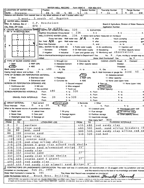
| Owner: Brecheisen, C.P. | Status: Constructed | ||
| Location: T34S, R38W, Sec. 16, SE SE NE | County: Stevens | ||
| Directions: from Hugoton, 5 mi W and 5 mi S | |||
| Latitude: 37.0909731 | Longitude: -101.4480293 | Datum NAD 27 | |
| Latitude: 37.0909992 | Longitude: -101.4484665 | Datum NAD 83 | |
| Longitude and latitude calculated by Survey from township-range-section-quarter calls. Only good to within the quarter call accuracy. | |||
| View well on interactive map | |||
| General Info | ||
| Well Depth: 520 ft. | Elevation: ft. | |
| Static Water Level: 236 ft. | Est. Yield: gpm. | |
| Comp. Date: 24-Feb-1999 | Well Use: Monitoring well/observation/piezometer | |
| DWR Applic. #: | Other ID: | |
| Driller Info | ||
| Driller: Houck Bros. Drilling | License #: 164 | |
| Scanned Form | View scan |
|
Chemical Sample Submitted?:
Water Well disinfected?: | ||
| Casing Info | ||
| Casing Type:
Casing Joints: |
Diam: in. to ft | |
| Casing height above land surface: in
Casing Weight: lbs/ft Wall thickness or gauge no.: | ||
| Screen and Perforation Info | ||
| Screen Type: | Screen Openings: | |
| Screen-perforated intervals | From: ft to ft | |
| Gravel pack intervals | From: ft to ft | |
| Grout Info | ||
| Grout used: | From: to ft | |
| Source of Possible Contamination | ||
| Source: | ||
| Direction from well: | Distance: ft | |
| Lithologic Log
(Log data entered by KGS.) | ||
| From: 0 ft. to 2 ft. | surface | |
| From: 2 ft. to 50 ft. | fine sand | |
| From: 50 ft. to 80 ft. | medium sand | |
| From: 80 ft. to 100 ft. | coarse sand | |
| From: 100 ft. to 125 ft. | gray clay | |
| From: 125 ft. to 140 ft. | coarse sand | |
| From: 140 ft. to 210 ft. | red clay with lime shells | |
| From: 210 ft. to 270 ft. | brown and gray clay with hard rock shells | |
| From: 270 ft. to 310 ft. | coarse sand with cemented strips | |
| From: 310 ft. to 330 ft. | sandy clay | |
| From: 330 ft. to 357 ft. | coarse sand | |
| From: 357 ft. to 376 ft. | sandy clay with lime shells | |
| From: 376 ft. to 403 ft. | coarse sand and gravel | |
| From: 403 ft. to 440 ft. | red sandy clay | |
| From: 440 ft. to 455 ft. | red sandy clay with small sand strips | |
| From: 455 ft. to 480 ft. | red sandy clay | |
| From: 480 ft. to 500 ft. | medium sand with clay breakers | |
| From: 500 ft. to 510 ft. | red sandy clay with fine red sand | |
| From: 510 ft. to 520 ft. | red bed | |