|
|
|
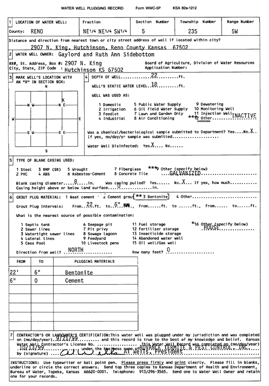
Specific Water Well Detail |
|
|
| Location Info | |||
| Owner: Sidebottom, Gaylord and Ruth Ann | Status: Plugged | ||
| Location: T23S, R5W, Sec. 5, NE NE SW | County: Reno | ||
| Directions: 2907 N King, Hutchinson | |||
| Latitude: 38.0784514 | Longitude: -97.8954664 | Datum NAD 27 | |
| Latitude: 38.0784625 | Longitude: -97.8957954 | Datum NAD 83 | |
| Longitude and latitude calculated by Survey from township-range-section-quarter calls. Only good to within the quarter call accuracy. | |||
| View well on interactive map | |||
| General Info | ||
| Well Depth: 22 ft. | Elevation: ft. | |
| Static Water Level: 18 ft. | Est. Yield: gpm. | |
| Comp. Date: 21-Sep-1999 | Well Use: (unstated)/abandoned | |
| DWR Applic. #: | Other ID: | |
| Driller Info | ||
| Driller: Advance Termite and Pest Control, Inc. | License #: | |
| Scanned Form | View scan |
| Casing Info | ||
|
Casing Type:
Diam: in. Casing height above land surface: in | ||
| Grout Info | ||
| Grout used: | From: to ft | |
| Source of Possible Contamination | ||
| Source: | ||
| Direction from well: | Distance: ft | |