|
|
|
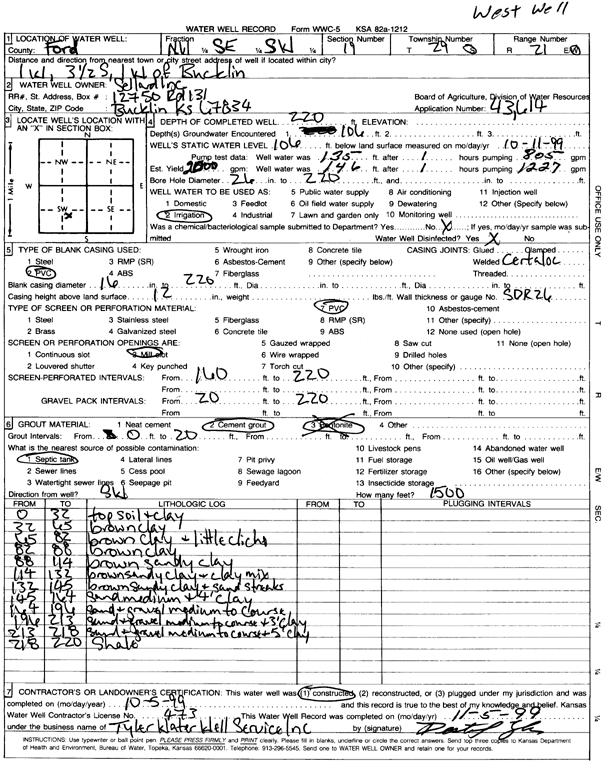
Specific Water Well Detail |
|
|
| Location Info | |||
| Owner: Sellard Inc | Status: Constructed | ||
| Location: T29S, R21W, Sec. 19, NW SE SW | County: Ford | ||
| Directions: from Bucklin: 1 mi W, 3.5 mi S | |||
| Latitude: 37.4998064 | Longitude: -99.6596812 | Datum NAD 27 | |
| Latitude: 37.4998276 | Longitude: -99.6600833 | Datum NAD 83 | |
| Longitude and latitude calculated by Survey from township-range-section-quarter calls. Only good to within the quarter call accuracy. | |||
| View well on interactive map | |||
| General Info | ||
| Well Depth: 220 ft. | Elevation: ft. | |
| Static Water Level: 106 ft. | Est. Yield: 2000 gpm. | |
| Comp. Date: 05-Oct-1999 | Well Use: Irrigation | |
| DWR Applic. #: 43614 | Other ID: West Well | |
| Links | |
| No Wizard information available. | |
| View info from WIMAS Water Right Data base... | |
| Driller Info | ||
| Driller: Tyler Water Well Service, Inc. | License #: 473 | |
| Scanned Form | View scan |
|
Chemical Sample Submitted?:
Water Well disinfected?: | ||
| Casing Info | ||
| Casing Type:
Casing Joints: |
Diam: in. to ft | |
| Casing height above land surface: in
Casing Weight: lbs/ft Wall thickness or gauge no.: | ||
| Screen and Perforation Info | ||
| Screen Type: | Screen Openings: | |
| Screen-perforated intervals | From: ft to ft | |
| Gravel pack intervals | From: ft to ft | |
| Grout Info | ||
| Grout used: | From: to ft | |
| Source of Possible Contamination | ||
| Source: | ||
| Direction from well: | Distance: ft | |
| Lithologic Log
(Log data entered by KGS.) | ||
| From: 0 ft. to 32 ft. | topsoil and clay | |
| From: 32 ft. to 65 ft. | brown clay | |
| From: 65 ft. to 82 ft. | brown clay and little caliche | |
| From: 82 ft. to 88 ft. | brown clay | |
| From: 88 ft. to 114 ft. | brown sandy clay | |
| From: 114 ft. to 132 ft. | brown sandy clay and clay mix | |
| From: 132 ft. to 145 ft. | brown sandy clay and sand streaks | |
| From: 145 ft. to 164 ft. | sand medium and 4 feet clay | |
| From: 164 ft. to 196 ft. | sand and gravel medium to coarse | |
| From: 196 ft. to 213 ft. | sand and gravel medium to coarse and 3 feet clay | |
| From: 213 ft. to 218 ft. | sand and gravel medium to coarse and 5 feet clay | |
| From: 218 ft. to 220 ft. | shale | |