|
|
|
Specific Water Well Detail |
|
|
| Location Info | |||
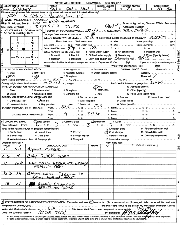
| Owner: Conoco Inc. | Status: Constructed | ||
| Location: T21S, R15E, Sec. 22, SW SW NW | County: Coffey | ||
| Directions: 1124 N 4th St, Burlington | |||
| Latitude: 38.2074414 | Longitude: -95.7554805 | Datum NAD 27 | |
| Latitude: 38.2074631 | Longitude: -95.7557449 | Datum NAD 83 | |
| Longitude and latitude calculated by Survey from township-range-section-quarter calls. Only good to within the quarter call accuracy. | |||
| View well on interactive map | |||
| General Info | ||
| Well Depth: 20.6 ft. | Elevation: ft. | |
| Static Water Level: 15.13 ft. | Est. Yield: gpm. | |
| Comp. Date: 23-Jun-1999 | Well Use: Monitoring well/observation/piezometer | |
| DWR Applic. #: | Other ID: MW 7 | |
| Driller Info | ||
| Driller: Tetra Tech Drilling Services | License #: 614 | |
| Scanned Form | View scan |
|
Chemical Sample Submitted?:
Water Well disinfected?: | ||
| Casing Info | ||
| Casing Type:
Casing Joints: |
Diam: in. to ft | |
| Casing height above land surface: in
Casing Weight: lbs/ft Wall thickness or gauge no.: | ||
| Screen and Perforation Info | ||
| Screen Type: | Screen Openings: | |
| Screen-perforated intervals | From: ft to ft | |
| Gravel pack intervals | From: ft to ft | |
| Grout Info | ||
| Grout used: | From: to ft | |
| Source of Possible Contamination | ||
| Source: | ||
| Direction from well: | Distance: ft | |
| Lithologic Log
(Log data entered by KGS.) | ||
| From: 0 ft. to .6 ft. | asphalt and concrete | |
| From: .6 ft. to 4 ft. | clay, black, soft | |
| From: 4 ft. to 12.5 ft. | fat clay, brown to orange, mottled, firm | |
| From: 12.5 ft. to 18 ft. | clayey sand, brown to gray, mottled, moist | |
| From: 18 ft. to 21 ft. | gravely clayey sand, brown to black | |