|
|
|
Specific Water Well Detail |
|
|
| Location Info | |||
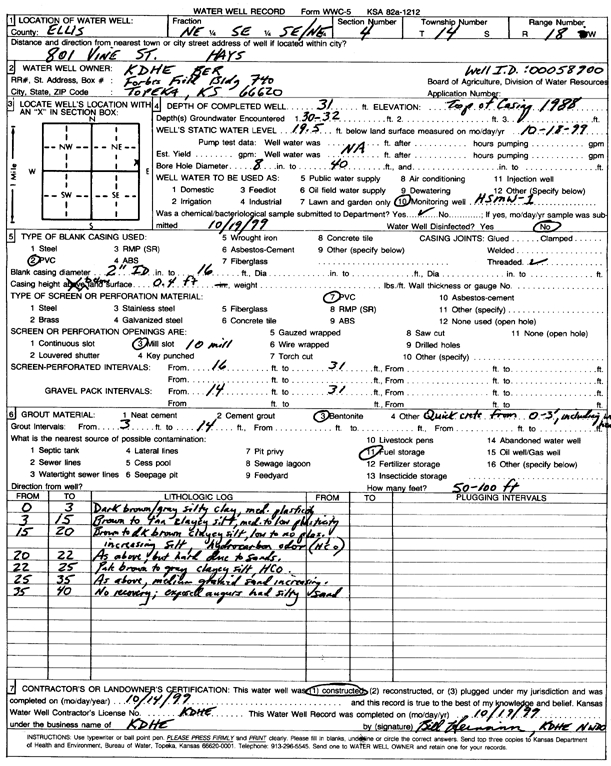
| Owner: KDHE-BER | Status: Constructed | ||
| Location: T14S, R18W, Sec. 4, NE SE SE NE | County: Ellis | ||
| Directions: 801 Vine St, Hays (id 00058900) | |||
| Latitude: 38.865107 | Longitude: -99.318213 | Datum NAD 27 | |
| Latitude: 38.8651188 | Longitude: -99.3185942 | Datum NAD 83 | |
| Longitude and latitude calculated by Survey from township-range-section-quarter calls. Only good to within the quarter call accuracy. | |||
| View well on interactive map | |||
| General Info | ||
| Well Depth: 31 ft. | Elevation: ft. | |
| Static Water Level: 19.5 ft. | Est. Yield: gpm. | |
| Comp. Date: 14-Oct-1999 | Well Use: Monitoring well/observation/piezometer | |
| DWR Applic. #: | Other ID: HSMW 1 | |
| Driller Info | ||
| Driller: KDHE | License #: | |
| Scanned Form | View scan |
|
Chemical Sample Submitted?:
Water Well disinfected?: | ||
| Casing Info | ||
| Casing Type:
Casing Joints: |
Diam: in. to ft | |
| Casing height above land surface: in
Casing Weight: lbs/ft Wall thickness or gauge no.: | ||
| Screen and Perforation Info | ||
| Screen Type: | Screen Openings: | |
| Screen-perforated intervals | From: ft to ft | |
| Gravel pack intervals | From: ft to ft | |
| Grout Info | ||
| Grout used: | From: to ft | |
| Source of Possible Contamination | ||
| Source: | ||
| Direction from well: | Distance: ft | |
| Lithologic Log
(Log data entered by KGS.) | ||
| From: 0 ft. to 3 ft. | dark brown-gray silty clay, medium plasticity | |
| From: 3 ft. to 15 ft. | brown to tan clayey silt, medium to low plasticity | |
| From: 15 ft. to 20 ft. | brown to dark brown clayey silt, low to no plasticity, increasing silt, hydrocarbon odor | |
| From: 20 ft. to 22 ft. | brown to dark brown clayey silt, hard due to sand | |
| From: 22 ft. to 25 ft. | pale brown to gray clayey silt | |
| From: 25 ft. to 35 ft. | pale brown to gray clayey silt, increasing medium sand | |
| From: 35 ft. to 40 ft. | unknown | |