|
|
|
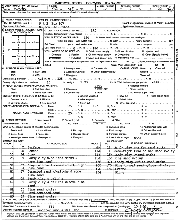
Specific Water Well Detail |
|
|
| Location Info | |||
| Owner: Pfannenstiel, Felix | Status: Constructed | ||
| Location: T3S, R22W, Sec. 17, SE SE SE | County: Norton | ||
| Directions: | |||
| Latitude: 39.7853053 | Longitude: -99.8152102 | Datum NAD 27 | |
| Latitude: 39.7853112 | Longitude: -99.8156068 | Datum NAD 83 | |
| Longitude and latitude calculated by Survey from township-range-section-quarter calls. Only good to within the quarter call accuracy. | |||
| View well on interactive map | |||
| General Info | ||
| Well Depth: 175 ft. | Elevation: ft. | |
| Static Water Level: 130 ft. | Est. Yield: gpm. | |
| Comp. Date: 02-Sep-1999 | Well Use: Domestic | |
| DWR Applic. #: | Other ID: | |
| Driller Info | ||
| Driller: Woofter Pump & Well, Inc. | License #: 554 | |
| Scanned Form | View scan |
|
Chemical Sample Submitted?:
Water Well disinfected?: | ||
| Casing Info | ||
| Casing Type:
Casing Joints: |
Diam: in. to ft | |
| Casing height above land surface: in
Casing Weight: lbs/ft Wall thickness or gauge no.: | ||
| Screen and Perforation Info | ||
| Screen Type: | Screen Openings: | |
| Screen-perforated intervals | From: ft to ft | |
| Gravel pack intervals | From: ft to ft | |
| Grout Info | ||
| Grout used: | From: to ft | |
| Source of Possible Contamination | ||
| Source: | ||
| Direction from well: | Distance: ft | |
| Lithologic Log
(Log data entered by KGS.) | ||
| From: 0 ft. to 2 ft. | surface | |
| From: 2 ft. to 20 ft. | loess | |
| From: 20 ft. to 26 ft. | clay | |
| From: 26 ft. to 39 ft. | sandy clay with caliche streaks and some fine sand | |
| From: 39 ft. to 62 ft. | clay, caliche, and cemented sand, tight | |
| From: 62 ft. to 64 ft. | fine sand | |
| From: 64 ft. to 67 ft. | cemented sand with caliche and some fine sand | |
| From: 67 ft. to 69 ft. | sandy clay and caliche | |
| From: 69 ft. to 82 ft. | sandy clay and caliche with some fine sand | |
| From: 82 ft. to 85 ft. | fine sand with clay | |
| From: 85 ft. to 86 ft. | hard cemented sand | |
| From: 86 ft. to 89 ft. | fine sand with clay | |
| From: 89 ft. to 114 ft. | sandy clay with a few sand streaks | |
| From: 114 ft. to 118 ft. | semi-tight fine to medium sand with clay | |
| From: 118 ft. to 154 ft. | sandy clay with sand streaks | |
| From: 154 ft. to 156 ft. | fine sand with clay | |
| From: 156 ft. to 160 ft. | sandy clay with fine sand streaks | |
| From: 160 ft. to 170 ft. | fine to medium sand with lots of clay | |
| From: 170 ft. to 176 ft. | ochre | |
| From: 176 ft. to ft. | flint | |