|
|
|
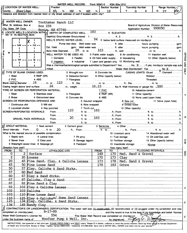
Specific Water Well Detail |
|
|
| Location Info | |||
| Owner: Toothaker Ranch LLC | Status: Constructed | ||
| Location: T8S, R27W, Sec. 18, N2 NW NE | County: Sheridan | ||
| Directions: | |||
| Latitude: 39.3637084 | Longitude: -100.3744294 | Datum NAD 27 | |
| Latitude: 39.3637129 | Longitude: -100.3748461 | Datum NAD 83 | |
| Longitude and latitude calculated by Survey from township-range-section-quarter calls. Only good to within the quarter call accuracy. | |||
| View well on interactive map | |||
| General Info | ||
| Well Depth: 183 ft. | Elevation: ft. | |
| Static Water Level: 94 ft. | Est. Yield: gpm. | |
| Comp. Date: 17-Aug-1999 | Well Use: Irrigation | |
| DWR Applic. #: | Other ID: | |
| Links | |
| No Wizard information available. | |
| View info from WIMAS Water Right Data base... | |
| Driller Info | ||
| Driller: Woofter Pump & Well, Inc. | License #: 554 | |
| Scanned Form | View scan |
|
Chemical Sample Submitted?:
Water Well disinfected?: | ||
| Casing Info | ||
| Casing Type:
Casing Joints: |
Diam: in. to ft | |
| Casing height above land surface: in
Casing Weight: lbs/ft Wall thickness or gauge no.: | ||
| Screen and Perforation Info | ||
| Screen Type: | Screen Openings: | |
| Screen-perforated intervals | From: ft to ft | |
| Gravel pack intervals | From: ft to ft | |
| Grout Info | ||
| Grout used: | From: to ft | |
| Source of Possible Contamination | ||
| Source: | ||
| Direction from well: | Distance: ft | |
| Lithologic Log
(Log data entered by KGS.) | ||
| From: 0 ft. to 2 ft. | Surface | |
| From: 2 ft. to 20 ft. | Loess | |
| From: 20 ft. to 45 ft. | Fine sand, clay, and caliche lenses | |
| From: 45 ft. to 50 ft. | Fine loose sand | |
| From: 50 ft. to 57 ft. | Clay, caliche and sand streaks | |
| From: 57 ft. to 60 ft. | Medium sand | |
| From: 60 ft. to 67 ft. | Clay and sand streaks | |
| From: 67 ft. to 87 ft. | Caliche, clay and sand | |
| From: 87 ft. to 92 ft. | Fine sand and clay | |
| From: 92 ft. to 102 ft. | Clay and caliche lenses | |
| From: 102 ft. to 103 ft. | Caliche | |
| From: 103 ft. to 110 ft. | Fine loose sand | |
| From: 110 ft. to 125 ft. | Clay and caliche with some sand lenses | |
| From: 125 ft. to 134 ft. | Clay, caliche, and sand streaks | |
| From: 134 ft. to 149 ft. | Sandy clay | |
| From: 149 ft. to 170 ft. | Medium sand and gravel | |
| From: 170 ft. to 173 ft. | Clay | |
| From: 173 ft. to 178 ft. | Medium sand and gravel | |
| From: 178 ft. to 183 ft. | Ochre | |