|
|
|
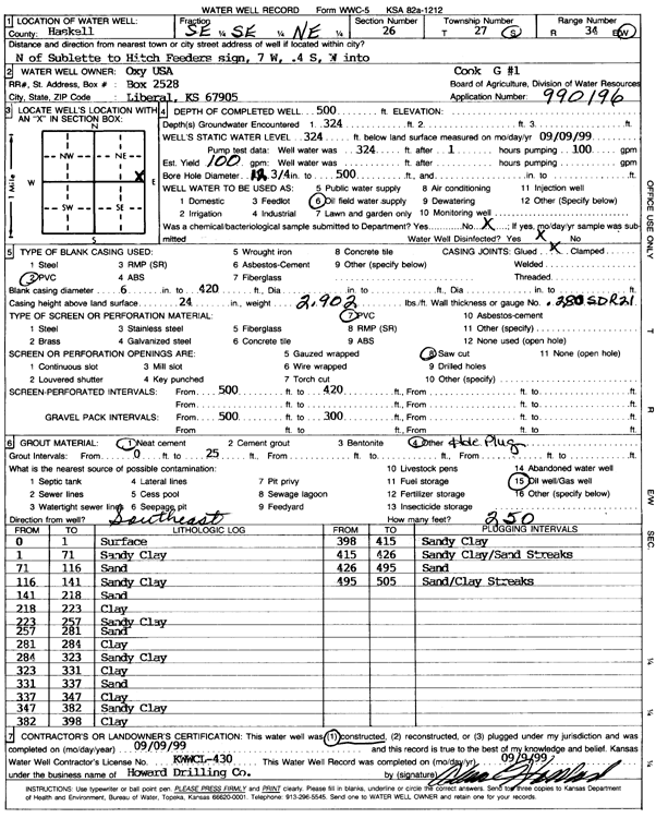
Specific Water Well Detail |
|
|
| Location Info | |||
| Owner: Oxy USA, Inc. | Status: Constructed | ||
| Location: T27S, R34W, Sec. 26, SE SE NE | County: Haskell | ||
| Directions: from Sublette: N to Hitch Feeders sign, 7 mi W, .4 mi S, W into site | |||
| Latitude: 37.672118 | Longitude: -100.9996355 | Datum NAD 27 | |
| Latitude: 37.672142 | Longitude: -101.000082 | Datum NAD 83 | |
| Longitude and latitude calculated by Survey from township-range-section-quarter calls. Only good to within the quarter call accuracy. | |||
| View well on interactive map | |||
| General Info | ||
| Well Depth: 500 ft. | Elevation: ft. | |
| Static Water Level: 324 ft. | Est. Yield: 100 gpm. | |
| Comp. Date: 09-Sep-1999 | Well Use: Oil Field Water Supply | |
| DWR Applic. #: 990196 | Other ID: Cook G 1 | |
| Links | |
| No Wizard information available. | |
| View info from WIMAS Water Right Data base... | |
| Driller Info | ||
| Driller: Howard Drilling Company AG, LLC | License #: 430 | |
| Scanned Form | View scan |
|
Chemical Sample Submitted?:
Water Well disinfected?: | ||
| Casing Info | ||
| Casing Type:
Casing Joints: |
Diam: in. to ft | |
| Casing height above land surface: in
Casing Weight: lbs/ft Wall thickness or gauge no.: | ||
| Screen and Perforation Info | ||
| Screen Type: | Screen Openings: | |
| Screen-perforated intervals | From: ft to ft | |
| Gravel pack intervals | From: ft to ft | |
| Grout Info | ||
| Grout used: | From: to ft | |
| Source of Possible Contamination | ||
| Source: | ||
| Direction from well: | Distance: ft | |
| Lithologic Log
(Log data entered by KGS.) | ||
| From: 0 ft. to 1 ft. | surface | |
| From: 1 ft. to 71 ft. | sandy clay | |
| From: 71 ft. to 116 ft. | sand | |
| From: 116 ft. to 141 ft. | sandy clay | |
| From: 141 ft. to 218 ft. | sand | |
| From: 218 ft. to 223 ft. | clay | |
| From: 223 ft. to 257 ft. | sandy clay | |
| From: 257 ft. to 281 ft. | sand | |
| From: 281 ft. to 284 ft. | clay | |
| From: 284 ft. to 323 ft. | sandy clay | |
| From: 323 ft. to 331 ft. | clay | |
| From: 331 ft. to 337 ft. | sand | |
| From: 337 ft. to 347 ft. | clay | |
| From: 347 ft. to 382 ft. | sandy clay | |
| From: 382 ft. to 398 ft. | clay | |
| From: 398 ft. to 415 ft. | sandy clay | |
| From: 415 ft. to 426 ft. | sandy clay/sand streaks | |
| From: 426 ft. to 495 ft. | sand | |
| From: 495 ft. to 505 ft. | sand/clay streaks | |