|
|
|
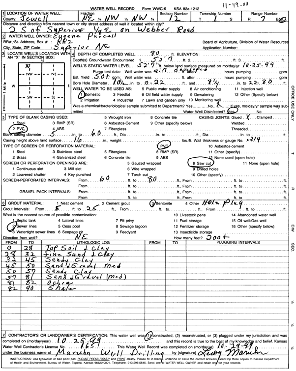
Specific Water Well Detail |
|
|
| Location Info | |||
| Owner: Purcell, Eugene | Status: Constructed | ||
| Location: T1S, R7W, Sec. 12, NE NW NW | County: Jewell | ||
| Directions: from Superior, NE, 2 mi S, 0.13 mi E on Webber Rd | |||
| Latitude: 39.9857356 | Longitude: -98.057469 | Datum NAD 27 | |
| Latitude: 39.9857495 | Longitude: -98.0577912 | Datum NAD 83 | |
| Longitude and latitude calculated by Survey from township-range-section-quarter calls. Only good to within the quarter call accuracy. | |||
| View well on interactive map | |||
| General Info | ||
| Well Depth: 80 ft. | Elevation: ft. | |
| Static Water Level: 52.5 ft. | Est. Yield: 50 gpm. | |
| Comp. Date: 25-Oct-1999 | Well Use: Domestic | |
| DWR Applic. #: | Other ID: | |
| Driller Info | ||
| Driller: Maruhn Well Drilling, Inc. | License #: 165 | |
| Scanned Form | View scan |
|
Chemical Sample Submitted?:
Water Well disinfected?: | ||
| Casing Info | ||
| Casing Type:
Casing Joints: |
Diam: in. to ft | |
| Casing height above land surface: in
Casing Weight: lbs/ft Wall thickness or gauge no.: | ||
| Screen and Perforation Info | ||
| Screen Type: | Screen Openings: | |
| Screen-perforated intervals | From: ft to ft | |
| Gravel pack intervals | From: ft to ft | |
| Grout Info | ||
| Grout used: | From: to ft | |
| Source of Possible Contamination | ||
| Source: | ||
| Direction from well: | Distance: ft | |
| Lithologic Log
(Log data entered by KGS.) | ||
| From: 0 ft. to 28 ft. | top soil and clay | |
| From: 28 ft. to 32 ft. | fine sand and clay | |
| From: 32 ft. to 45 ft. | sandy clay | |
| From: 45 ft. to 50 ft. | sand and gravel, medium | |
| From: 50 ft. to 57 ft. | sandy clay | |
| From: 57 ft. to 81 ft. | sand and gravel, medium | |
| From: 81 ft. to 82 ft. | ochre | |
| From: 82 ft. to 90 ft. | shale | |