|
|
|
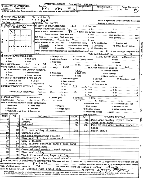
Specific Water Well Detail |
|
|
| Location Info | |||
| Owner: Schmidt, Chris | Status: Constructed | ||
| Location: T4S, R31W, Sec. 31, NW NW NW | County: Rawlins | ||
| Directions: | |||
| Latitude: 39.6683408 | Longitude: -100.8506178 | Datum NAD 27 | |
| Latitude: 39.6683441 | Longitude: -100.8510474 | Datum NAD 83 | |
| Longitude and latitude calculated by Survey from township-range-section-quarter calls. Only good to within the quarter call accuracy. | |||
| View well on interactive map | |||
| General Info | ||
| Well Depth: 114 ft. | Elevation: ft. | |
| Static Water Level: 78 ft. | Est. Yield: gpm. | |
| Comp. Date: 08-Aug-1999 | Well Use: Domestic | |
| DWR Applic. #: | Other ID: | |
| Driller Info | ||
| Driller: Woofter Pump & Well Inc. | License #: 554 | |
| Scanned Form | View scan |
|
Chemical Sample Submitted?:
Water Well disinfected?: | ||
| Casing Info | ||
| Casing Type:
Casing Joints: |
Diam: in. to ft | |
| Casing height above land surface: in
Casing Weight: lbs/ft Wall thickness or gauge no.: | ||
| Screen and Perforation Info | ||
| Screen Type: | Screen Openings: | |
| Screen-perforated intervals | From: ft to ft | |
| Gravel pack intervals | From: ft to ft | |
| Grout Info | ||
| Grout used: | From: to ft | |
| Source of Possible Contamination | ||
| Source: | ||
| Direction from well: | Distance: ft | |
| Lithologic Log
(Log data entered by KGS.) | ||
| From: 0 ft. to 2 ft. | surface | |
| From: 2 ft. to 3 ft. | loess | |
| From: 3 ft. to 5 ft. | medium sand | |
| From: 5 ft. to 7 ft. | clay | |
| From: 7 ft. to 10 ft. | hard rock with clay streaks | |
| From: 10 ft. to 12 ft. | cemented sand | |
| From: 12 ft. to 17 ft. | medium sand with cemented streaks | |
| From: 17 ft. to 25 ft. | clay with joint clay and some sand | |
| From: 25 ft. to 27 ft. | clay and caliche | |
| From: 27 ft. to 30 ft. | clay, caliche, cemented sand, and some sand | |
| From: 30 ft. to 33 ft. | hard cemented sand | |
| From: 33 ft. to 48 ft. | cemented sand with clay and sand streaks | |
| From: 48 ft. to 57 ft. | fine sand with clay | |
| From: 57 ft. to 60 ft. | tight fine sand with a layers of clay | |
| From: 60 ft. to 70 ft. | sandy clay with a few fine sand streaks | |
| From: 70 ft. to 91 ft. | fine sand with clay layers, loose | |
| From: 91 ft. to 93 ft. | tight fine sand | |
| From: 93 ft. to 108 ft. | fine to medium sand with clay lenses, fairly loose | |
| From: 108 ft. to 114 ft. | black shale | |