|
|
|
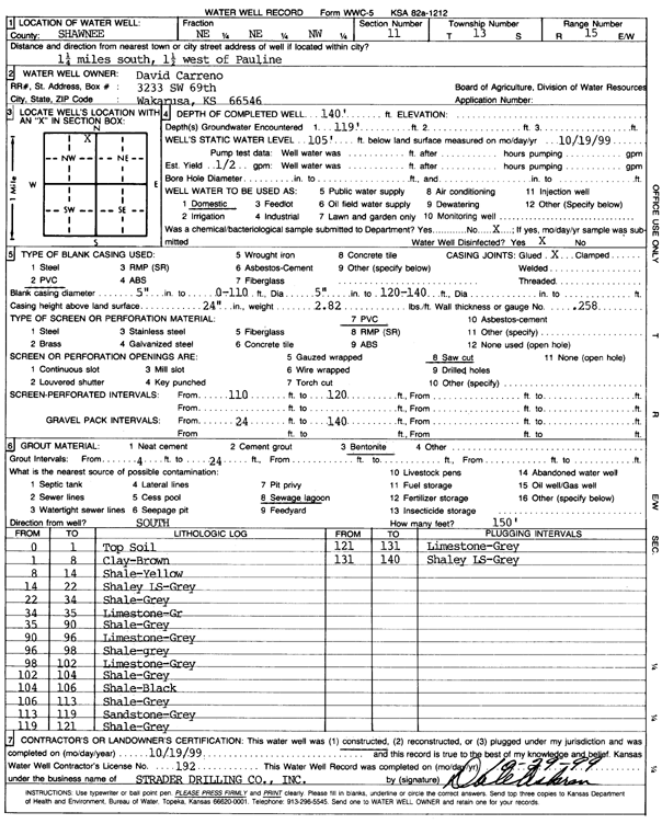
Specific Water Well Detail |
|
|
| Location Info | |||
| Owner: Carreno, David | Status: Constructed | ||
| Location: T13S, R15E, Sec. 11, NE NE NW | County: Shawnee | ||
| Directions: from Pauline: 1.25 mi S, 1.5 mi W | |||
| Latitude: 38.9415902 | Longitude: -95.7164155 | Datum NAD 27 | |
| Latitude: 38.9415924 | Longitude: -95.7166763 | Datum NAD 83 | |
| Longitude and latitude calculated by Survey from township-range-section-quarter calls. Only good to within the quarter call accuracy. | |||
| View well on interactive map | |||
| General Info | ||
| Well Depth: 140 ft. | Elevation: ft. | |
| Static Water Level: 105 ft. | Est. Yield: .5 gpm. | |
| Comp. Date: 19-Oct-1999 | Well Use: Domestic | |
| DWR Applic. #: | Other ID: | |
| Driller Info | ||
| Driller: Strader Drilling Co., Inc. | License #: 182 | |
| Scanned Form | View scan |
|
Chemical Sample Submitted?:
Water Well disinfected?: | ||
| Casing Info | ||
| Casing Type:
Casing Joints: |
Diam: in. to ft | |
| Casing height above land surface: in
Casing Weight: lbs/ft Wall thickness or gauge no.: | ||
| Screen and Perforation Info | ||
| Screen Type: | Screen Openings: | |
| Screen-perforated intervals | From: ft to ft | |
| Gravel pack intervals | From: ft to ft | |
| Grout Info | ||
| Grout used: | From: to ft | |
| Source of Possible Contamination | ||
| Source: | ||
| Direction from well: | Distance: ft | |
| Lithologic Log
(Log data entered by KGS.) | ||
| From: 0 ft. to 1 ft. | top soil | |
| From: 1 ft. to 8 ft. | clay, brown | |
| From: 8 ft. to 14 ft. | shale, yellow | |
| From: 14 ft. to 22 ft. | shaley limestone, gray | |
| From: 22 ft. to 34 ft. | shale, gray | |
| From: 34 ft. to 35 ft. | limestone, gray | |
| From: 35 ft. to 90 ft. | shale, gray | |
| From: 90 ft. to 96 ft. | limestone, gray | |
| From: 96 ft. to 98 ft. | shale, gray | |
| From: 98 ft. to 102 ft. | limestone, gray | |
| From: 102 ft. to 104 ft. | shale, gray | |
| From: 104 ft. to 106 ft. | shale, black | |
| From: 106 ft. to 113 ft. | shale, gray | |
| From: 113 ft. to 119 ft. | sandstone, gray | |
| From: 119 ft. to 121 ft. | shale, gray | |
| From: 121 ft. to 131 ft. | limestone, gray | |
| From: 131 ft. to 140 ft. | shaley limestone, gray | |