|
|
|
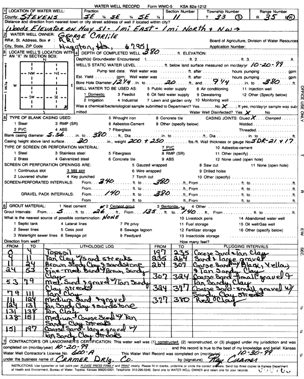
Specific Water Well Detail |
|
|
| Location Info | |||
| Owner: Carlile, George | Status: Constructed | ||
| Location: T33S, R35W, Sec. 11, SE SE SE | County: Stevens | ||
| Directions: from Woods Elevator on Hwy 51, 1 mi E and 1 mi N | |||
| Latitude: 37.1855736 | Longitude: -101.0861552 | Datum NAD 27 | |
| Latitude: 37.1855984 | Longitude: -101.0865962 | Datum NAD 83 | |
| Longitude and latitude calculated by Survey from township-range-section-quarter calls. Only good to within the quarter call accuracy. | |||
| View well on interactive map | |||
| General Info | ||
| Well Depth: 380 ft. | Elevation: ft. | |
| Static Water Level: ft. | Est. Yield: gpm. | |
| Comp. Date: 20-Oct-1999 | Well Use: Domestic | |
| DWR Applic. #: | Other ID: | |
| Driller Info | ||
| Driller: Cramer Drilling Co. | License #: 600 | |
| Scanned Form | View scan |
|
Chemical Sample Submitted?:
Water Well disinfected?: | ||
| Casing Info | ||
| Casing Type:
Casing Joints: |
Diam: in. to ft | |
| Casing height above land surface: in
Casing Weight: lbs/ft Wall thickness or gauge no.: | ||
| Screen and Perforation Info | ||
| Screen Type: | Screen Openings: | |
| Screen-perforated intervals | From: ft to ft | |
| Gravel pack intervals | From: ft to ft | |
| Grout Info | ||
| Grout used: | From: to ft | |
| Source of Possible Contamination | ||
| Source: | ||
| Direction from well: | Distance: ft | |
| Lithologic Log
(Log data entered by KGS.) | ||
| From: 0 ft. to 4 ft. | topsoil | |
| From: 4 ft. to 11 ft. | tan clay with sand streaks | |
| From: 11 ft. to 24 ft. | brown sandy clay and sandstone | |
| From: 24 ft. to 53 ft. | fine-medium sand with brown sandy clay | |
| From: 53 ft. to 79 ft. | medium sand and gravel with tan sandy clay streaks | |
| From: 79 ft. to 111 ft. | tan clay | |
| From: 111 ft. to 124 ft. | medium sand and gravel | |
| From: 124 ft. to 131 ft. | tan sandy clay and sandstone | |
| From: 131 ft. to 138 ft. | tan clay | |
| From: 138 ft. to 151 ft. | medium-coarse sand with tan sandy clay streaks | |
| From: 151 ft. to 197 ft. | coarse sand- large gravel with tan sandy clay streaks | |
| From: 197 ft. to 235 ft. | coarse sand and tan clay | |
| From: 235 ft. to 264 ft. | sand and large gravel | |
| From: 264 ft. to 307 ft. | coarse sand with black, yellow, and tan sandy clay | |
| From: 307 ft. to 324 ft. | coarse sand- small gravel and tan sandy clay | |
| From: 324 ft. to 377 ft. | coarse sand- small gravel with sandy clay streaks | |
| From: 377 ft. to 380 ft. | red clay | |