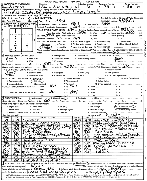
KGS Home Page Water Well Data base Specific Water Well Detail
Water Resources

Well T35S, R38W, Sec. 6, SW SW SW, Action: Constructed

Location Info
Owner: Kramer, James Status: Constructed
Location: T35S, R38W, Sec. 6, SW SW SW County: Stevens
Directions: from Feterita, 9 mi S and 1 mi W
Latitude: 37.0256955 Longitude: -101.499558 Datum NAD 27
Latitude: 37.0257228 Longitude: -101.4999956 Datum NAD 83
Longitude and latitude calculated by Survey from township-range-section-quarter calls. Only good to within the quarter call accuracy.
View well on interactive map
General Info
Well Depth: 567 ft. Elevation: 3275 ft.
Static Water Level: 254 ft. Est. Yield: 3000 gpm.
Comp. Date: 21-Oct-1999 Well Use: Irrigation
DWR Applic. #: 4329700 Other ID:
Links
No Wizard information available.
View info from WIMAS Water Right Data base...
Driller Info
Driller: Howard Drilling Company AG, LLC License #: 430
Scanned Form
View form(s) on screen Download scan(s)
The download files contain one or more TIFF images compressed into a ZIP archive. Your browser may be already set up to decompress these files. The TIFFs are 300 dpi archival-quality scans of the WWC5 forms and can be viewed by software like Adobe PhotoShop.
Chemical Sample Submitted?:
Water Well disinfected?:
Casing Info
Casing Type:
Casing Joints:
Diam: in. to ft
Casing height above land surface: in
Casing Weight: lbs/ft
Wall thickness or gauge no.:
Screen and Perforation Info
Screen Type: Screen Openings:
Screen-perforated intervals From: ft to ft
Gravel pack intervals From: ft to ft
Grout Info
Grout used: From: to ft
Source of Possible Contamination
Source:
Direction from well: Distance: ft
Lithologic Log
(Log data entered by KGS.)
From: 0 ft. to 230 ft. surface
From: 230 ft. to 240 ft. medium-coarse sand
From: 240 ft. to 250 ft. medium-coarse sand with clay strip
From: 250 ft. to 260 ft. clay with 20% fine sand
From: 260 ft. to 270 ft. fine with 20% clay
From: 270 ft. to 290 ft. fine sand with med. Streak, 10% clay
From: 290 ft. to 310 ft. medium sand
From: 310 ft. to 320 ft. fine-medium sand
From: 320 ft. to 330 ft. fine sand
From: 330 ft. to 340 ft. fine-medium sand
From: 340 ft. to 350 ft. fine-medium sand with 20% clay
From: 350 ft. to 380 ft. medium sand with clay streak
From: 380 ft. to 400 ft. fine-medium sand with clay streak
From: 400 ft. to 410 ft. medium-coarse with clay streak
From: 410 ft. to 420 ft. fine sand with clay streak
From: 420 ft. to 430 ft. fine-medium with 20% clay
From: 430 ft. to 460 ft. medium-coarse with clay streak
From: 460 ft. to 470 ft. fine-med, 10% coarse, 10% clay
From: 470 ft. to 480 ft. fine-medium with 40% clay
From: 480 ft. to 490 ft. fine sand
From: 490 ft. to 500 ft. fine-medium with clay streak
From: 500 ft. to 510 ft. medium-coarse with 10% clay
From: 510 ft. to 520 ft. medium sand
From: 520 ft. to 530 ft. medium-coarse with 10% clay
From: 530 ft. to 540 ft. coarse with 20% clay
From: 540 ft. to 550 ft. red clay
From: 550 ft. to 567 ft. red bed

Kansas Geological Survey
Comments to kgs-webadmin@ku.edu
URL=http://www.kgs.ku.edu/Magellan/WaterWell/index.html
Display Programs Updated January 2, 2025
Data added continuously.