|
|
|
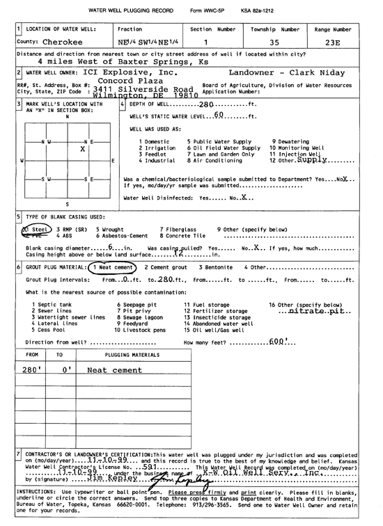
Specific Water Well Detail |
|
|
| Location Info | |||
| Owner: ICI Explosive, Inc. | Status: Plugged | ||
| Location: T35S, R23E, Sec. 1, NE SW NE | County: Cherokee | ||
| Directions: from Baxter Springs: 4 mi W | |||
| Latitude: 37.0266529 | Longitude: -94.8368652 | Datum NAD 27 | |
| Latitude: 37.026719 | Longitude: -94.837095 | Datum NAD 83 | |
| Longitude and latitude calculated by Survey from township-range-section-quarter calls. Only good to within the quarter call accuracy. | |||
| View well on interactive map | |||
| General Info | ||
| Well Depth: 280 ft. | Elevation: ft. | |
| Static Water Level: 60 ft. | Est. Yield: gpm. | |
| Comp. Date: 10-Nov-1999 | Well Use: Oil Field Water Supply | |
| DWR Applic. #: | Other ID: | |
| Driller Info | ||
| Driller: K-W Oil Well Service, Inc. | License #: 591 | |
| Scanned Form | View scan |
| Casing Info | ||
|
Casing Type:
Diam: in. Casing height above land surface: in | ||
| Grout Info | ||
| Grout used: | From: to ft | |
| Source of Possible Contamination | ||
| Source: | ||
| Direction from well: | Distance: ft | |