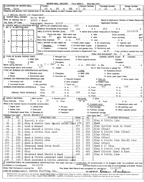
Lithologic Log
(Log data entered by KGS.) |
| |
From: 0 ft. to 30 ft. |
Topsoil and clay |
| |
From: 30 ft. to 45 ft. |
Clay and little lime (hard) and a little fine sand |
| |
From: 45 ft. to 54 ft. |
Sand and Gravel |
| |
From: 54 ft. to 60 ft. |
Lime (hard) and little clay |
| |
From: 60 ft. to 70 ft. |
Clay and little fine sand |
| |
From: 70 ft. to 75 ft. |
Sand |
| |
From: 75 ft. to 100 ft. |
Sand and little clay |
| |
From: 100 ft. to 109 ft. |
Clay and little lime |
| |
From: 109 ft. to 117 ft. |
Sand and Gravel |
| |
From: 117 ft. to 118 ft. |
Cemented Sand (very hard) |
| |
From: 118 ft. to 133 ft. |
Sand and Gravel |
| |
From: 133 ft. to 140 ft. |
Clay |
| |
From: 140 ft. to 145 ft. |
Cemented Sand (hard) and Sand |
| |
From: 145 ft. to 150 ft. |
Sand and little cemented coarse sand |
| |
From: 150 ft. to 165 ft. |
Coarse sand and little cemented sand |
| |
From: 165 ft. to 170 ft. |
Clay and little lime |
| |
From: 170 ft. to 197 ft. |
Sand |
| |
From: 197 ft. to 210 ft. |
Clay (yellow turn to blue) |
| |
From: 210 ft. to 225 ft. |
Clay (blue) |
| |
From: 225 ft. to 240 ft. |
Clay and little lime (blue) |
| |
From: 240 ft. to 255 ft. |
Clay (blue) |
| |
From: 255 ft. to 315 ft. |
Clay (blue) |
| |
From: 315 ft. to 320 ft. |
Clay and little lime (hard) blue |
| |
From: 320 ft. to 355 ft. |
Clay (blue) |
| |
From: 355 ft. to 375 ft. |
Sand and 1 foot Clay |
| |
From: 375 ft. to 405 ft. |
Clay and little lime (hard) |
| |
From: 405 ft. to 420 ft. |
Sand (little fine) and Lime |
| |
From: 420 ft. to 422 ft. |
Clay and little lime |