|
|
|
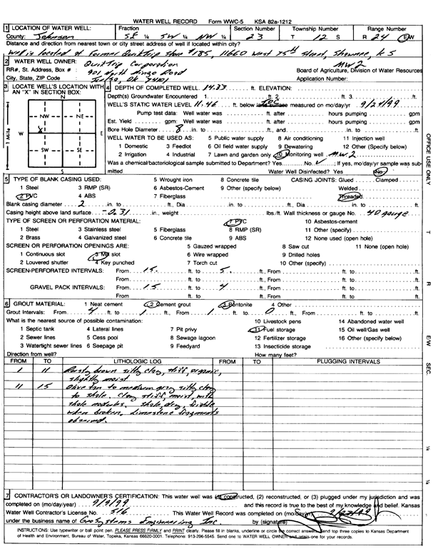
Specific Water Well Detail |
|
|
| Location Info | |||
| Owner: QuikTrip Corp. | Status: Constructed | ||
| Location: T12S, R24E, Sec. 23, SE SW NW | County: Johnson | ||
| Directions: 11660 West 75th St, Shawnee | |||
| Latitude: 38.9937638 | Longitude: -94.7199644 | Datum NAD 27 | |
| Latitude: 38.9937697 | Longitude: -94.7202021 | Datum NAD 83 | |
| Longitude and latitude calculated by Survey from township-range-section-quarter calls. Only good to within the quarter call accuracy. | |||
| View well on interactive map | |||
| General Info | ||
| Well Depth: 14 ft. | Elevation: ft. | |
| Static Water Level: 11 ft. | Est. Yield: gpm. | |
| Comp. Date: 09-Sep-1999 | Well Use: Monitoring well/observation/piezometer | |
| DWR Applic. #: | Other ID: MW 2 | |
| Driller Info | ||
| Driller: Geo Systems Engineering, Inc. | License #: 516 | |
| Scanned Form | View scan |
|
Chemical Sample Submitted?:
Water Well disinfected?: | ||
| Casing Info | ||
| Casing Type:
Casing Joints: |
Diam: in. to ft | |
| Casing height above land surface: in
Casing Weight: lbs/ft Wall thickness or gauge no.: | ||
| Screen and Perforation Info | ||
| Screen Type: | Screen Openings: | |
| Screen-perforated intervals | From: ft to ft | |
| Gravel pack intervals | From: ft to ft | |
| Grout Info | ||
| Grout used: | From: to ft | |
| Source of Possible Contamination | ||
| Source: | ||
| Direction from well: | Distance: ft | |
| Lithologic Log
(Log data entered by KGS.) | ||
| From: 1 ft. to 11 ft. | rusty brown silty clay, stiff, organic, slightly moist | |
| From: 11 ft. to 15 ft. | olive tan to medium gray silty clay to shale; clay stiff, moist, with shale nodules; shale, dry, friable when broken; limestone fragments observed | |