|
|
|
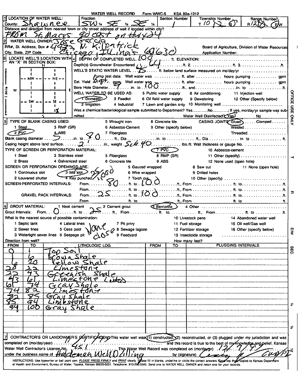
Specific Water Well Detail |
|
|
| Location Info | |||
| Owner: Garcia, Jose | Status: Constructed | ||
| Location: T10S, R12E, Sec. 1, SW SE SE | County: Shawnee | ||
| Directions: from St. Marys go east on Hwy 24 | |||
| Latitude: 39.2028723 | Longitude: -96.0200492 | Datum NAD 27 | |
| Latitude: 39.2028696 | Longitude: -96.020319 | Datum NAD 83 | |
| Longitude and latitude calculated by Survey from township-range-section-quarter calls. Only good to within the quarter call accuracy. | |||
| View well on interactive map | |||
| General Info | ||
| Well Depth: 100 ft. | Elevation: ft. | |
| Static Water Level: 75 ft. | Est. Yield: gpm. | |
| Comp. Date: 01-Nov-1999 | Well Use: Domestic | |
| DWR Applic. #: | Other ID: | |
| Driller Info | ||
| Driller: Haldeman Well Drilling | License #: 451 | |
| Scanned Form | View scan |
|
Chemical Sample Submitted?:
Water Well disinfected?: | ||
| Casing Info | ||
| Casing Type:
Casing Joints: |
Diam: in. to ft | |
| Casing height above land surface: in
Casing Weight: lbs/ft Wall thickness or gauge no.: | ||
| Screen and Perforation Info | ||
| Screen Type: | Screen Openings: | |
| Screen-perforated intervals | From: ft to ft | |
| Gravel pack intervals | From: ft to ft | |
| Grout Info | ||
| Grout used: | From: to ft | |
| Source of Possible Contamination | ||
| Source: | ||
| Direction from well: | Distance: ft | |
| Lithologic Log
(Log data entered by KGS.) | ||
| From: 0 ft. to 1 ft. | top soil | |
| From: 1 ft. to 6 ft. | brown shale | |
| From: 6 ft. to 20 ft. | yellow shale | |
| From: 20 ft. to 22 ft. | limestone | |
| From: 22 ft. to 43 ft. | greenish shale | |
| From: 43 ft. to 61 ft. | limestone | |
| From: 61 ft. to 74 ft. | gray shale | |
| From: 74 ft. to 82 ft. | limestone | |
| From: 82 ft. to 85 ft. | gray shale | |
| From: 85 ft. to 94 ft. | limestone | |
| From: 94 ft. to 100 ft. | gray shale | |