|
|
|
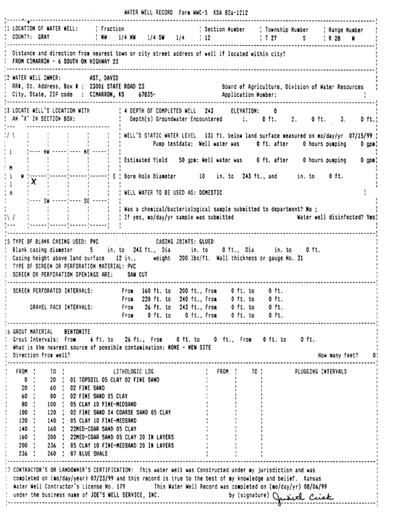
Specific Water Well Detail |
|
|
| Location Info | |||
| Owner: Ast, David | Status: Constructed | ||
| Location: T27S, R27W, Sec. 12, NW NW SW | County: Gray | ||
| Directions: from Cimarron: 6 mi S on Hwy 23 | |||
| Latitude: 37.7143132 | Longitude: -100.2314846 | Datum NAD 27 | |
| Latitude: 37.7143349 | Longitude: -100.2319037 | Datum NAD 83 | |
| Longitude and latitude calculated by Survey from township-range-section-quarter calls. Only good to within the quarter call accuracy. | |||
| View well on interactive map | |||
| General Info | ||
| Well Depth: 243 ft. | Elevation: ft. | |
| Static Water Level: 131 ft. | Est. Yield: gpm. | |
| Comp. Date: 23-Jul-1999 | Well Use: Domestic | |
| DWR Applic. #: | Other ID: | |
| Driller Info | ||
| Driller: Joe's Well Service, Inc. | License #: 179 | |
| Scanned Form | View scan |
|
Chemical Sample Submitted?:
Water Well disinfected?: | ||
| Casing Info | ||
| Casing Type:
Casing Joints: |
Diam: in. to ft | |
| Casing height above land surface: in
Casing Weight: lbs/ft Wall thickness or gauge no.: | ||
| Screen and Perforation Info | ||
| Screen Type: | Screen Openings: | |
| Screen-perforated intervals | From: ft to ft | |
| Gravel pack intervals | From: ft to ft | |
| Grout Info | ||
| Grout used: | From: to ft | |
| Source of Possible Contamination | ||
| Source: | ||
| Direction from well: | Distance: ft | |
| Lithologic Log
(Log data entered by KGS.) | ||
| From: 0 ft. to 20 ft. | TOPSOIL CLAY FINE SAND | |
| From: 20 ft. to 60 ft. | FINE SAND | |
| From: 60 ft. to 80 ft. | FINE SAND CLAY | |
| From: 80 ft. to 100 ft. | CLAY FINE TO MEDIUM SAND | |
| From: 100 ft. to 120 ft. | FINE SAND COARSE SAND CLAY | |
| From: 120 ft. to 140 ft. | CLAY FINE TO MEDIUM SAND | |
| From: 140 ft. to 160 ft. | MEDIUM TO COARSE SAND CLAY | |
| From: 160 ft. to 200 ft. | MEDIUM TO COARSE SAND CLAY IN LAYERS | |
| From: 200 ft. to 236 ft. | CLAY FINE TO MEDIUM SAND IN LAYERS | |
| From: 236 ft. to 260 ft. | BLUE SHALE | |