|
|
|
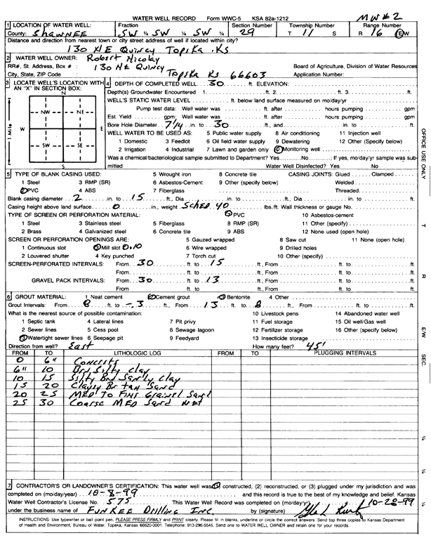
Specific Water Well Detail |
|
|
| Location Info | |||
| Owner: Nicolay, Robert | Status: Constructed | ||
| Location: T11S, R16E, Sec. 29, SW SW SW | County: Shawnee | ||
| Directions: 130 NE Quincy, Topeka | |||
| Latitude: 39.0596996 | Longitude: -95.6681796 | Datum NAD 27 | |
| Latitude: 39.0596996 | Longitude: -95.6684386 | Datum NAD 83 | |
| Longitude and latitude calculated by Survey from township-range-section-quarter calls. Only good to within the quarter call accuracy. | |||
| View well on interactive map | |||
| General Info | ||
| Well Depth: 30 ft. | Elevation: ft. | |
| Static Water Level: ft. | Est. Yield: gpm. | |
| Comp. Date: 08-Oct-1999 | Well Use: Monitoring well/observation/piezometer | |
| DWR Applic. #: | Other ID: MW 2 | |
| Driller Info | ||
| Driller: Funkee Drilling Service | License #: 575 | |
| Scanned Form | View scan |
|
Chemical Sample Submitted?:
Water Well disinfected?: | ||
| Casing Info | ||
| Casing Type:
Casing Joints: |
Diam: in. to ft | |
| Casing height above land surface: in
Casing Weight: lbs/ft Wall thickness or gauge no.: | ||
| Screen and Perforation Info | ||
| Screen Type: | Screen Openings: | |
| Screen-perforated intervals | From: ft to ft | |
| Gravel pack intervals | From: ft to ft | |
| Grout Info | ||
| Grout used: | From: to ft | |
| Source of Possible Contamination | ||
| Source: | ||
| Direction from well: | Distance: ft | |
| Lithologic Log
(Log data entered by KGS.) | ||
| From: 0 ft. to .5 ft. | concrete | |
| From: .5 ft. to 10 ft. | brown silty clay | |
| From: 10 ft. to 15 ft. | silty brown sandy clay | |
| From: 15 ft. to 20 ft. | clayey brown tan sand | |
| From: 20 ft. to 25 ft. | medium to fine sand | |
| From: 25 ft. to 30 ft. | coarse medium sand, wet | |