|
|
|
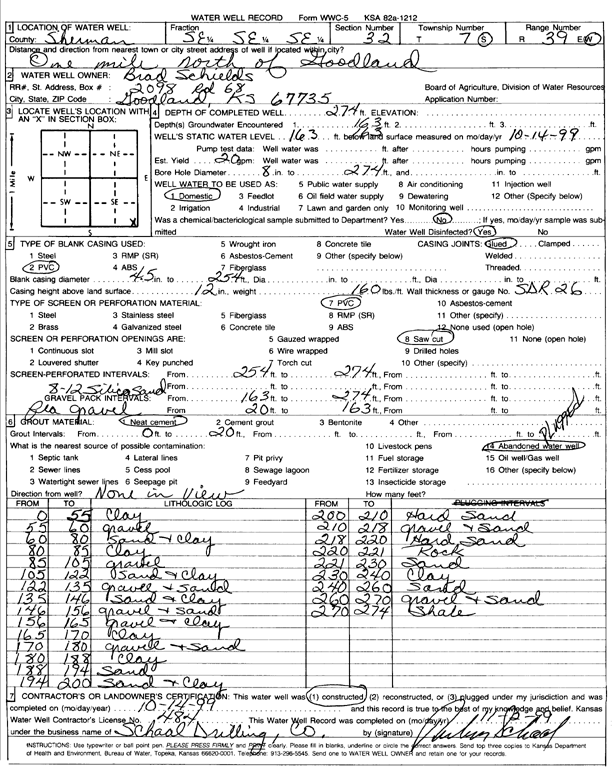
Specific Water Well Detail |
|
|
| Location Info | |||
| Owner: Schields, Brad | Status: Constructed | ||
| Location: T7S, R39W, Sec. 32, SE SE SE | County: Sherman | ||
| Directions: from Goodland, 1 mi N | |||
| Latitude: 39.3956961 | Longitude: -101.6895576 | Datum NAD 27 | |
| Latitude: 39.3956951 | Longitude: -101.6900071 | Datum NAD 83 | |
| Longitude and latitude calculated by Survey from township-range-section-quarter calls. Only good to within the quarter call accuracy. | |||
| View well on interactive map | |||
| General Info | ||
| Well Depth: 274 ft. | Elevation: ft. | |
| Static Water Level: 163 ft. | Est. Yield: 20 gpm. | |
| Comp. Date: 14-Oct-1999 | Well Use: Domestic | |
| DWR Applic. #: | Other ID: | |
| Driller Info | ||
| Driller: Ruben T. Schaal Drilling Co. | License #: 484 | |
| Scanned Form | View scan |
|
Chemical Sample Submitted?:
Water Well disinfected?: | ||
| Casing Info | ||
| Casing Type:
Casing Joints: |
Diam: in. to ft | |
| Casing height above land surface: in
Casing Weight: lbs/ft Wall thickness or gauge no.: | ||
| Screen and Perforation Info | ||
| Screen Type: | Screen Openings: | |
| Screen-perforated intervals | From: ft to ft | |
| Gravel pack intervals | From: ft to ft | |
| Grout Info | ||
| Grout used: | From: to ft | |
| Source of Possible Contamination | ||
| Source: | ||
| Direction from well: | Distance: ft | |
| Lithologic Log
(Log data entered by KGS.) | ||
| From: 0 ft. to 55 ft. | Clay | |
| From: 55 ft. to 60 ft. | Gravel | |
| From: 60 ft. to 80 ft. | Sand and clay | |
| From: 80 ft. to 85 ft. | Clay | |
| From: 85 ft. to 105 ft. | Gravel | |
| From: 105 ft. to 122 ft. | Sand and clay | |
| From: 122 ft. to 135 ft. | Gravel and sand | |
| From: 135 ft. to 146 ft. | Sand and clay | |
| From: 146 ft. to 156 ft. | Gravel and sand | |
| From: 156 ft. to 165 ft. | Gravel and clay | |
| From: 165 ft. to 170 ft. | Clay | |
| From: 170 ft. to 180 ft. | Gravel and sand | |
| From: 180 ft. to 188 ft. | Clay | |
| From: 188 ft. to 194 ft. | Sand | |
| From: 194 ft. to 200 ft. | Sand and clay | |
| From: 200 ft. to 210 ft. | Hard sand | |
| From: 210 ft. to 218 ft. | Gravel and sand | |
| From: 218 ft. to 220 ft. | Hard sand | |
| From: 220 ft. to 221 ft. | Rock | |
| From: 221 ft. to 230 ft. | Sand | |
| From: 230 ft. to 240 ft. | Clay | |
| From: 240 ft. to 260 ft. | Sand | |
| From: 260 ft. to 270 ft. | Gravel and sand | |
| From: 270 ft. to 274 ft. | Shale | |