|
|
|
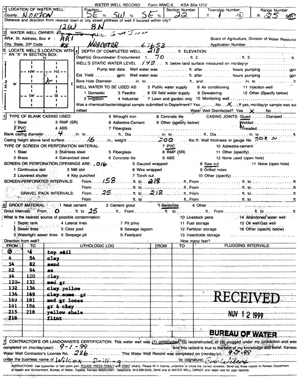
Specific Water Well Detail |
|
|
| Location Info | |||
| Owner: G-M, Inc. | Status: Constructed | ||
| Location: T1S, R25W, Sec. 22, SE SW SE | County: Norton | ||
| Directions: 12 mi W, 8 mi N | |||
| Latitude: 39.9445218 | Longitude: -100.1189463 | Datum NAD 27 | |
| Latitude: 39.9445273 | Longitude: -100.1193576 | Datum NAD 83 | |
| Longitude and latitude calculated by Survey from township-range-section-quarter calls. Only good to within the quarter call accuracy. | |||
| View well on interactive map | |||
| General Info | ||
| Well Depth: 218 ft. | Elevation: ft. | |
| Static Water Level: 148 ft. | Est. Yield: gpm. | |
| Comp. Date: 01-Sep-1999 | Well Use: Domestic | |
| DWR Applic. #: | Other ID: | |
| Driller Info | ||
| Driller: Bob Wilcox Well Drilling | License #: 286 | |
| Scanned Form | View scan |
|
Chemical Sample Submitted?:
Water Well disinfected?: | ||
| Casing Info | ||
| Casing Type:
Casing Joints: |
Diam: in. to ft | |
| Casing height above land surface: in
Casing Weight: lbs/ft Wall thickness or gauge no.: | ||
| Screen and Perforation Info | ||
| Screen Type: | Screen Openings: | |
| Screen-perforated intervals | From: ft to ft | |
| Gravel pack intervals | From: ft to ft | |
| Grout Info | ||
| Grout used: | From: to ft | |
| Source of Possible Contamination | ||
| Source: | ||
| Direction from well: | Distance: ft | |
| Lithologic Log
(Log data entered by KGS.) | ||
| From: 0 ft. to 4 ft. | topsoil | |
| From: 4 ft. to 54 ft. | clay | |
| From: 54 ft. to 82 ft. | sand | |
| From: 82 ft. to 94 ft. | sandstone | |
| From: 94 ft. to 120 ft. | clay | |
| From: 120 ft. to 132 ft. | medium gravel | |
| From: 132 ft. to 136 ft. | clay yellow | |
| From: 136 ft. to 169 ft. | clay some gravel | |
| From: 169 ft. to 181 ft. | medium gravel loose | |
| From: 181 ft. to 186 ft. | gravel and clay | |
| From: 215 ft. to 218 ft. | yellow shale | |
| From: 218 ft. to ft. | flint | |