|
|
|
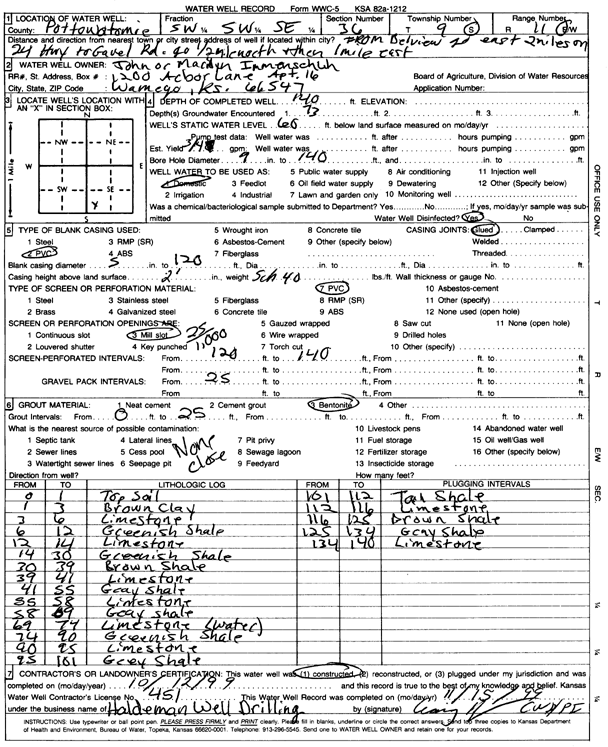
Specific Water Well Detail |
|
|
| Location Info | |||
| Owner: Immenschuh, John and Marilyn | Status: Constructed | ||
| Location: T9S, R11E, Sec. 36, SW SW SE | County: Pottawatomie | ||
| Directions: from Belvue: 2 mi E on 24 Hwy to Gavel Rd, .5 mi N, 1 mi E | |||
| Latitude: 39.2177285 | Longitude: -96.1365717 | Datum NAD 27 | |
| Latitude: 39.2177253 | Longitude: -96.136844 | Datum NAD 83 | |
| Longitude and latitude calculated by Survey from township-range-section-quarter calls. Only good to within the quarter call accuracy. | |||
| View well on interactive map | |||
| General Info | ||
| Well Depth: 140 ft. | Elevation: ft. | |
| Static Water Level: 60 ft. | Est. Yield: .75 gpm. | |
| Comp. Date: 12-Oct-1999 | Well Use: Domestic | |
| DWR Applic. #: | Other ID: | |
| Driller Info | ||
| Driller: Haldeman Well Drilling & Pump Service | License #: 451 | |
| Scanned Form | View scan |
|
Chemical Sample Submitted?:
Water Well disinfected?: | ||
| Casing Info | ||
| Casing Type:
Casing Joints: |
Diam: in. to ft | |
| Casing height above land surface: in
Casing Weight: lbs/ft Wall thickness or gauge no.: | ||
| Screen and Perforation Info | ||
| Screen Type: | Screen Openings: | |
| Screen-perforated intervals | From: ft to ft | |
| Gravel pack intervals | From: ft to ft | |
| Grout Info | ||
| Grout used: | From: to ft | |
| Source of Possible Contamination | ||
| Source: | ||
| Direction from well: | Distance: ft | |
| Lithologic Log
(Log data entered by KGS.) | ||
| From: 0 ft. to 1 ft. | top soil | |
| From: 1 ft. to 3 ft. | brown clay | |
| From: 3 ft. to 6 ft. | limestone | |
| From: 6 ft. to 12 ft. | greenish shale | |
| From: 12 ft. to 14 ft. | limestone | |
| From: 14 ft. to 30 ft. | greenish shale | |
| From: 30 ft. to 39 ft. | brown shale | |
| From: 39 ft. to 41 ft. | limestone | |
| From: 41 ft. to 55 ft. | gray shale | |
| From: 55 ft. to 58 ft. | limestone | |
| From: 58 ft. to 69 ft. | gray shale | |
| From: 69 ft. to 74 ft. | limestone | |
| From: 74 ft. to 90 ft. | greenish shale | |
| From: 90 ft. to 95 ft. | limestone | |
| From: 95 ft. to 101 ft. | gray shale | |
| From: 101 ft. to 112 ft. | tan shale | |
| From: 112 ft. to 116 ft. | limestone | |
| From: 116 ft. to 125 ft. | brown shale | |
| From: 125 ft. to 134 ft. | gray shale | |
| From: 134 ft. to 140 ft. | limestone | |