|
|
|
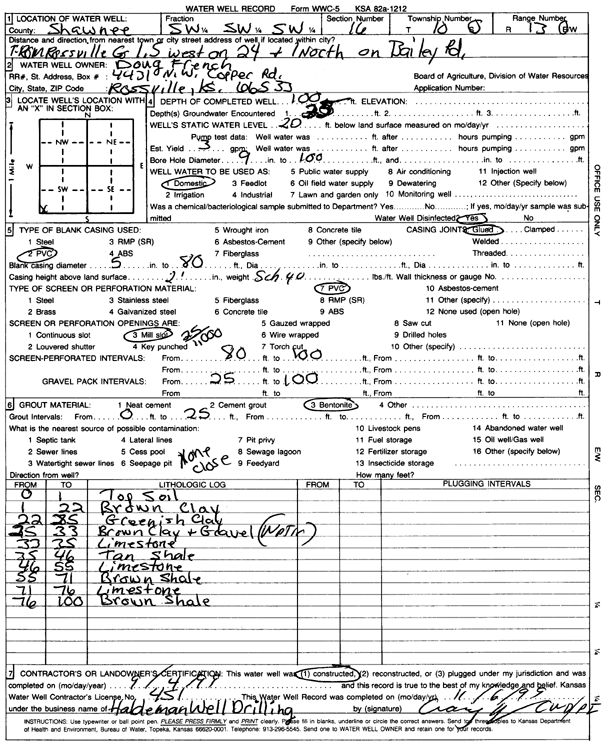
Specific Water Well Detail |
|
|
| Location Info | |||
| Owner: French, Doug | Status: Constructed | ||
| Location: T10S, R13E, Sec. 16, SW SW SW | County: Shawnee | ||
| Directions: from Rossville, 1.5 mi W on 24, 1 mi N on Bailey Rd. | |||
| Latitude: 39.1741736 | Longitude: -95.9787167 | Datum NAD 27 | |
| Latitude: 39.1741716 | Longitude: -95.9789852 | Datum NAD 83 | |
| Longitude and latitude calculated by Survey from township-range-section-quarter calls. Only good to within the quarter call accuracy. | |||
| View well on interactive map | |||
| General Info | ||
| Well Depth: 100 ft. | Elevation: ft. | |
| Static Water Level: 20 ft. | Est. Yield: 3 gpm. | |
| Comp. Date: 04-Sep-1999 | Well Use: Domestic | |
| DWR Applic. #: | Other ID: | |
| Driller Info | ||
| Driller: Holdeman Well Drilling | License #: 451 | |
| Scanned Form | View scan |
|
Chemical Sample Submitted?:
Water Well disinfected?: | ||
| Casing Info | ||
| Casing Type:
Casing Joints: |
Diam: in. to ft | |
| Casing height above land surface: in
Casing Weight: lbs/ft Wall thickness or gauge no.: | ||
| Screen and Perforation Info | ||
| Screen Type: | Screen Openings: | |
| Screen-perforated intervals | From: ft to ft | |
| Gravel pack intervals | From: ft to ft | |
| Grout Info | ||
| Grout used: | From: to ft | |
| Source of Possible Contamination | ||
| Source: | ||
| Direction from well: | Distance: ft | |
| Lithologic Log
(Log data entered by KGS.) | ||
| From: 0 ft. to 1 ft. | top soil | |
| From: 1 ft. to 22 ft. | brown clay | |
| From: 22 ft. to 25 ft. | greenish clay | |
| From: 25 ft. to 33 ft. | brown clay and gravel | |
| From: 33 ft. to 35 ft. | limestone | |
| From: 35 ft. to 46 ft. | tan shale | |
| From: 46 ft. to 55 ft. | limestone | |
| From: 55 ft. to 71 ft. | brown shale | |
| From: 71 ft. to 76 ft. | limestone | |
| From: 76 ft. to 100 ft. | brown shale | |