|
|
|
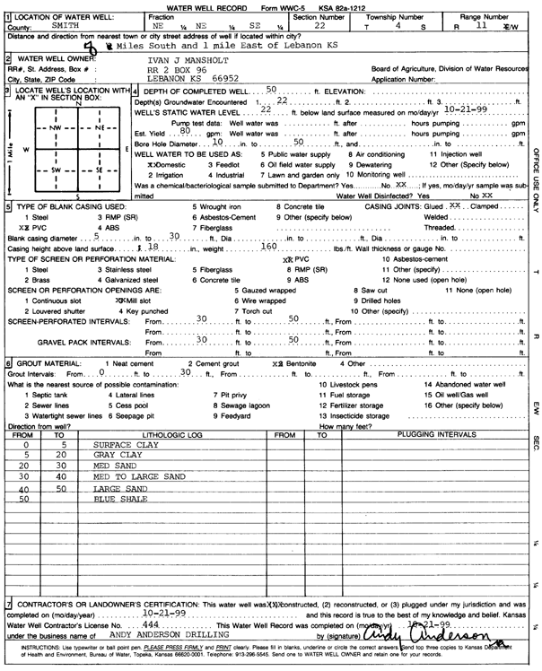
Specific Water Well Detail |
|
|
| Location Info | |||
| Owner: Mansholt, Ivan J. | Status: Constructed | ||
| Location: T4S, R11W, Sec. 22, NE NE SE | County: Smith | ||
| Directions: from Lebanon, 8 mi S and 1 mi E | |||
| Latitude: 39.6896452 | Longitude: -98.5427416 | Datum NAD 27 | |
| Latitude: 39.6896564 | Longitude: -98.5430842 | Datum NAD 83 | |
| Longitude and latitude calculated by Survey from township-range-section-quarter calls. Only good to within the quarter call accuracy. | |||
| View well on interactive map | |||
| General Info | ||
| Well Depth: 50 ft. | Elevation: ft. | |
| Static Water Level: 22 ft. | Est. Yield: 80 gpm. | |
| Comp. Date: 21-Oct-1999 | Well Use: Domestic | |
| DWR Applic. #: | Other ID: | |
| Driller Info | ||
| Driller: Andy Anderson Drilling | License #: 444 | |
| Scanned Form | View scan |
|
Chemical Sample Submitted?:
Water Well disinfected?: | ||
| Casing Info | ||
| Casing Type:
Casing Joints: |
Diam: in. to ft | |
| Casing height above land surface: in
Casing Weight: lbs/ft Wall thickness or gauge no.: | ||
| Screen and Perforation Info | ||
| Screen Type: | Screen Openings: | |
| Screen-perforated intervals | From: ft to ft | |
| Gravel pack intervals | From: ft to ft | |
| Grout Info | ||
| Grout used: | From: to ft | |
| Source of Possible Contamination | ||
| Source: | ||
| Direction from well: | Distance: ft | |
| Lithologic Log
(Log data entered by KGS.) | ||
| From: 0 ft. to 5 ft. | surface clay | |
| From: 5 ft. to 20 ft. | gray clay | |
| From: 20 ft. to 30 ft. | medium sand | |
| From: 30 ft. to 40 ft. | medium to large sand | |
| From: 40 ft. to 50 ft. | large sand | |
| From: 50 ft. to ft. | blue shale | |