|
|
|
Specific Water Well Detail |
|
|
| Location Info | |||
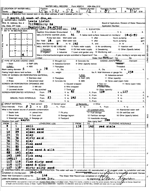
| Owner: Liebst, Lewis | Status: Constructed | ||
| Location: T31S, R11W, Sec. 12, SW SW SE | County: Barber | ||
| Directions: 7 mi N, 1.5 mi W of Sharon | |||
| Latitude: 37.3558083 | Longitude: -98.466608 | Datum NAD 27 | |
| Latitude: 37.3558294 | Longitude: -98.4669645 | Datum NAD 83 | |
| Longitude and latitude calculated by Survey from township-range-section-quarter calls. Only good to within the quarter call accuracy. | |||
| View well on interactive map | |||
| General Info | ||
| Well Depth: 142 ft. | Elevation: ft. | |
| Static Water Level: 41 ft. | Est. Yield: 10 gpm. | |
| Comp. Date: 05-Oct-1999 | Well Use: Domestic | |
| DWR Applic. #: | Other ID: | |
| Driller Info | ||
| Driller: Dean L. Lyman, Inc. | License #: 140 | |
| Scanned Form | View scan |
|
Chemical Sample Submitted?:
Water Well disinfected?: | ||
| Casing Info | ||
| Casing Type:
Casing Joints: |
Diam: in. to ft | |
| Casing height above land surface: in
Casing Weight: lbs/ft Wall thickness or gauge no.: | ||
| Screen and Perforation Info | ||
| Screen Type: | Screen Openings: | |
| Screen-perforated intervals | From: ft to ft | |
| Gravel pack intervals | From: ft to ft | |
| Grout Info | ||
| Grout used: | From: to ft | |
| Source of Possible Contamination | ||
| Source: | ||
| Direction from well: | Distance: ft | |
| Lithologic Log
(Log data entered by KGS.) | ||
| From: 0 ft. to 1 ft. | soil | |
| From: 1 ft. to 12 ft. | white sand | |
| From: 12 ft. to 29 ft. | clean sand | |
| From: 29 ft. to 34 ft. | clay | |
| From: 34 ft. to 36 ft. | dirty sand | |
| From: 36 ft. to 72 ft. | clay | |
| From: 72 ft. to 75 ft. | fine sand | |
| From: 75 ft. to 82 ft. | sand | |
| From: 82 ft. to 88 ft. | fine sand and silt | |
| From: 88 ft. to 103 ft. | clay | |
| From: 103 ft. to 109 ft. | fine sand | |
| From: 109 ft. to 117 ft. | clay | |
| From: 117 ft. to 119 ft. | fine dirty sand | |
| From: 119 ft. to 127 ft. | sand and clay | |
| From: 127 ft. to 138 ft. | dirty silty sand | |
| From: 138 ft. to 142 ft. | red shale | |