|
|
|
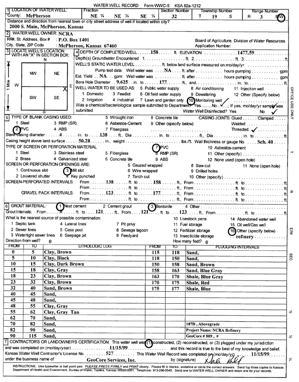
Specific Water Well Detail |
|
|
| Location Info | |||
| Owner: NCRA | Status: Constructed | ||
| Location: T19S, R3W, Sec. 32, NE NE SE | County: McPherson | ||
| Directions: 2000 S Main, McPherson | |||
| Latitude: 38.354024 | Longitude: -97.6677713 | Datum NAD 27 | |
| Latitude: 38.3540323 | Longitude: -97.6680917 | Datum NAD 83 | |
| Longitude and latitude calculated by Survey from township-range-section-quarter calls. Only good to within the quarter call accuracy. | |||
| View well on interactive map | |||
| General Info | ||
| Well Depth: 158 ft. | Elevation: 1477.59 ft. | |
| Static Water Level: ft. | Est. Yield: gpm. | |
| Comp. Date: 15-Nov-1999 | Well Use: Monitoring well/observation/piezometer | |
| DWR Applic. #: | Other ID: MW 107 D | |
| Driller Info | ||
| Driller: GeoCore Services Inc. | License #: 527 | |
| Scanned Form | View scan |
|
Chemical Sample Submitted?:
Water Well disinfected?: | ||
| Casing Info | ||
| Casing Type:
Casing Joints: |
Diam: in. to ft | |
| Casing height above land surface: in
Casing Weight: lbs/ft Wall thickness or gauge no.: | ||
| Screen and Perforation Info | ||
| Screen Type: | Screen Openings: | |
| Screen-perforated intervals | From: ft to ft | |
| Gravel pack intervals | From: ft to ft | |
| Grout Info | ||
| Grout used: | From: to ft | |
| Source of Possible Contamination | ||
| Source: | ||
| Direction from well: | Distance: ft | |
| Lithologic Log
(Log data entered by KGS.) | ||
| From: 0 ft. to 5 ft. | clay, brown | |
| From: 5 ft. to 10 ft. | clay, black | |
| From: 10 ft. to 15 ft. | clay, dark brown | |
| From: 15 ft. to 18 ft. | clay, gray | |
| From: 18 ft. to 23 ft. | clay, brown | |
| From: 23 ft. to 32 ft. | clay, brown | |
| From: 32 ft. to 40 ft. | sand, brown | |
| From: 40 ft. to 45 ft. | sand | |
| From: 45 ft. to 48 ft. | sand | |
| From: 48 ft. to 55 ft. | clay, gray | |
| From: 55 ft. to 62 ft. | clay, gray tan | |
| From: 62 ft. to 70 ft. | sand | |
| From: 70 ft. to 82 ft. | sand | |
| From: 82 ft. to 90 ft. | sand | |
| From: 90 ft. to 115 ft. | sand | |
| From: 115 ft. to 118 ft. | sand | |
| From: 118 ft. to 150 ft. | sand | |
| From: 150 ft. to 158 ft. | sand, brown | |
| From: 158 ft. to 163 ft. | sand, blue gray | |
| From: 163 ft. to 170 ft. | shale, blue gray | |
| From: 170 ft. to 175 ft. | shale, red | |
| From: 175 ft. to 177 ft. | shale, blue | |