|
|
|
Specific Water Well Detail |
|
|
| Location Info | |||
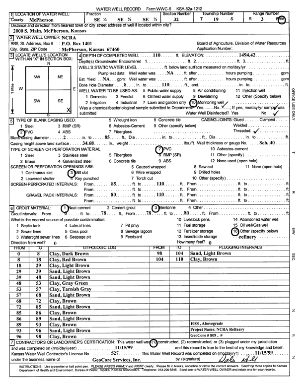
| Owner: NCRA | Status: Constructed | ||
| Location: T19S, R3W, Sec. 32, SE SE SE | County: McPherson | ||
| Directions: 2000 S Main, McPherson | |||
| Latitude: 38.3486309 | Longitude: -97.6678075 | Datum NAD 27 | |
| Latitude: 38.3486393 | Longitude: -97.668128 | Datum NAD 83 | |
| Longitude and latitude calculated by Survey from township-range-section-quarter calls. Only good to within the quarter call accuracy. | |||
| View well on interactive map | |||
| General Info | ||
| Well Depth: 110 ft. | Elevation: 1494.42 ft. | |
| Static Water Level: ft. | Est. Yield: gpm. | |
| Comp. Date: 15-Nov-1999 | Well Use: Monitoring well/observation/piezometer | |
| DWR Applic. #: | Other ID: MW 108 S | |
| Driller Info | ||
| Driller: GeoCore Services Inc. | License #: 527 | |
| Scanned Form | View scan |
|
Chemical Sample Submitted?:
Water Well disinfected?: | ||
| Casing Info | ||
| Casing Type:
Casing Joints: |
Diam: in. to ft | |
| Casing height above land surface: in
Casing Weight: lbs/ft Wall thickness or gauge no.: | ||
| Screen and Perforation Info | ||
| Screen Type: | Screen Openings: | |
| Screen-perforated intervals | From: ft to ft | |
| Gravel pack intervals | From: ft to ft | |
| Grout Info | ||
| Grout used: | From: to ft | |
| Source of Possible Contamination | ||
| Source: | ||
| Direction from well: | Distance: ft | |
| Lithologic Log
(Log data entered by KGS.) | ||
| From: 0 ft. to 8 ft. | clay, dark brown | |
| From: 8 ft. to 18 ft. | clay, red brown | |
| From: 18 ft. to 29 ft. | clay, light brown | |
| From: 29 ft. to 39 ft. | sand, light brown | |
| From: 39 ft. to 48 ft. | sand, light brown | |
| From: 48 ft. to 53 ft. | clay, gray green | |
| From: 53 ft. to 57 ft. | clay, tannish gray | |
| From: 57 ft. to 68 ft. | sand, light brown | |
| From: 68 ft. to 72 ft. | clay, brown | |
| From: 72 ft. to 85 ft. | sand, light brown | |
| From: 85 ft. to 86 ft. | clay, brown | |
| From: 86 ft. to 89 ft. | sand, light brown | |
| From: 89 ft. to 93 ft. | clay, brown | |
| From: 93 ft. to 96 ft. | sand, light brown | |
| From: 96 ft. to 98 ft. | clay, brown | |
| From: 98 ft. to 104 ft. | sand, light brown | |
| From: 104 ft. to 110 ft. | clay, brown | |