|
|
|
Specific Water Well Detail |
|
|
| Location Info | |||
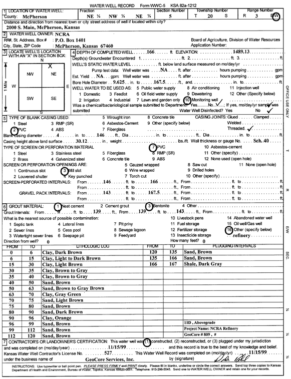
| Owner: NCRA | Status: Constructed | ||
| Location: T20S, R3W, Sec. 5, NE NW NE | County: McPherson | ||
| Directions: 2000 S Main, McPherson | |||
| Latitude: 38.34683 | Longitude: -97.6723917 | Datum NAD 27 | |
| Latitude: 38.3468384 | Longitude: -97.6727123 | Datum NAD 83 | |
| Longitude and latitude calculated by Survey from township-range-section-quarter calls. Only good to within the quarter call accuracy. | |||
| View well on interactive map | |||
| General Info | ||
| Well Depth: 166 ft. | Elevation: 1489.13 ft. | |
| Static Water Level: ft. | Est. Yield: gpm. | |
| Comp. Date: 15-Nov-1999 | Well Use: Monitoring well/observation/piezometer | |
| DWR Applic. #: | Other ID: MW 11 D | |
| Driller Info | ||
| Driller: GeoCore Services Inc. | License #: 527 | |
| Scanned Form | View scan |
|
Chemical Sample Submitted?:
Water Well disinfected?: | ||
| Casing Info | ||
| Casing Type:
Casing Joints: |
Diam: in. to ft | |
| Casing height above land surface: in
Casing Weight: lbs/ft Wall thickness or gauge no.: | ||
| Screen and Perforation Info | ||
| Screen Type: | Screen Openings: | |
| Screen-perforated intervals | From: ft to ft | |
| Gravel pack intervals | From: ft to ft | |
| Grout Info | ||
| Grout used: | From: to ft | |
| Source of Possible Contamination | ||
| Source: | ||
| Direction from well: | Distance: ft | |
| Lithologic Log
(Log data entered by KGS.) | ||
| From: 0 ft. to 6 ft. | clay, dark brown | |
| From: 6 ft. to 15 ft. | clay, light to dark brown | |
| From: 15 ft. to 30 ft. | clay, light brown | |
| From: 30 ft. to 35 ft. | clay, brown to gray | |
| From: 35 ft. to 40 ft. | clay, brown to gray | |
| From: 40 ft. to 50 ft. | sand, brown | |
| From: 50 ft. to 63 ft. | sand, brown to gray brown | |
| From: 63 ft. to 70 ft. | clay, gray green | |
| From: 70 ft. to 75 ft. | sand, light brown | |
| From: 75 ft. to 80 ft. | sand, brown | |
| From: 80 ft. to 90 ft. | sand, dark brown | |
| From: 90 ft. to 96 ft. | clay, orange | |
| From: 96 ft. to 99 ft. | sand, brown | |
| From: 99 ft. to 112 ft. | sand, brown | |
| From: 112 ft. to 120 ft. | sand, brown | |
| From: 120 ft. to 135 ft. | sand, brown | |
| From: 135 ft. to 166 ft. | sand, brown | |
| From: 166 ft. to 167 ft. | shale, dark gray | |