|
|
|
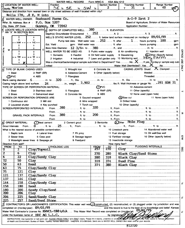
Specific Water Well Detail |
|
|
| Location Info | |||
| Owner: Seaboard Farms | Status: Constructed | ||
| Location: T31S, R40W, Sec. 2, SE SE SW | County: Morton | ||
| Directions: from Rolla, 17 mi N and 0.8 mi E, N into site | |||
| Latitude: 37.3747528 | Longitude: -101.638762 | Datum NAD 27 | |
| Latitude: 37.3747746 | Longitude: -101.6392055 | Datum NAD 83 | |
| Longitude and latitude calculated by Survey from township-range-section-quarter calls. Only good to within the quarter call accuracy. | |||
| View well on interactive map | |||
| General Info | ||
| Well Depth: 380 ft. | Elevation: ft. | |
| Static Water Level: 252 ft. | Est. Yield: gpm. | |
| Comp. Date: 01-Sep-1999 | Well Use: Domestic, Livestock | |
| DWR Applic. #: | Other ID: A-I-9 East 2 | |
| Links | |
| No Wizard information available. | |
| View info from WIMAS Water Right Data base... | |
| Driller Info | ||
| Driller: H.D.C. AG, LLC | License #: 652 | |
| Scanned Form | View scan |
|
Chemical Sample Submitted?:
Water Well disinfected?: | ||
| Casing Info | ||
| Casing Type:
Casing Joints: |
Diam: in. to ft | |
| Casing height above land surface: in
Casing Weight: lbs/ft Wall thickness or gauge no.: | ||
| Screen and Perforation Info | ||
| Screen Type: | Screen Openings: | |
| Screen-perforated intervals | From: ft to ft | |
| Gravel pack intervals | From: ft to ft | |
| Grout Info | ||
| Grout used: | From: to ft | |
| Source of Possible Contamination | ||
| Source: | ||
| Direction from well: | Distance: ft | |
| Lithologic Log
(Log data entered by KGS.) | ||
| From: 0 ft. to 2 ft. | clay/topsoil | |
| From: 2 ft. to 6 ft. | clay | |
| From: 6 ft. to 22 ft. | clay/sandy clay | |
| From: 22 ft. to 50 ft. | clay | |
| From: 50 ft. to 63 ft. | sand | |
| From: 63 ft. to 75 ft. | clay/sandy clay | |
| From: 75 ft. to 121 ft. | clay | |
| From: 121 ft. to 137 ft. | clay/sandy clay | |
| From: 137 ft. to 144 ft. | clay | |
| From: 144 ft. to 158 ft. | clay/sandy clay | |
| From: 158 ft. to 180 ft. | sand | |
| From: 180 ft. to 200 ft. | sandy clay/sand | |
| From: 200 ft. to 206 ft. | clay | |
| From: 206 ft. to 225 ft. | sand/sandy clay | |
| From: 225 ft. to 257 ft. | sand/sandstone | |
| From: 257 ft. to 270 ft. | clay | |
| From: 270 ft. to 280 ft. | black clay/sandstone | |
| From: 280 ft. to 318 ft. | black clay | |
| From: 318 ft. to 374 ft. | sand fine | |
| From: 374 ft. to 380 ft. | black clay | |