|
|
|
Specific Water Well Detail |
|
|
| Location Info | |||
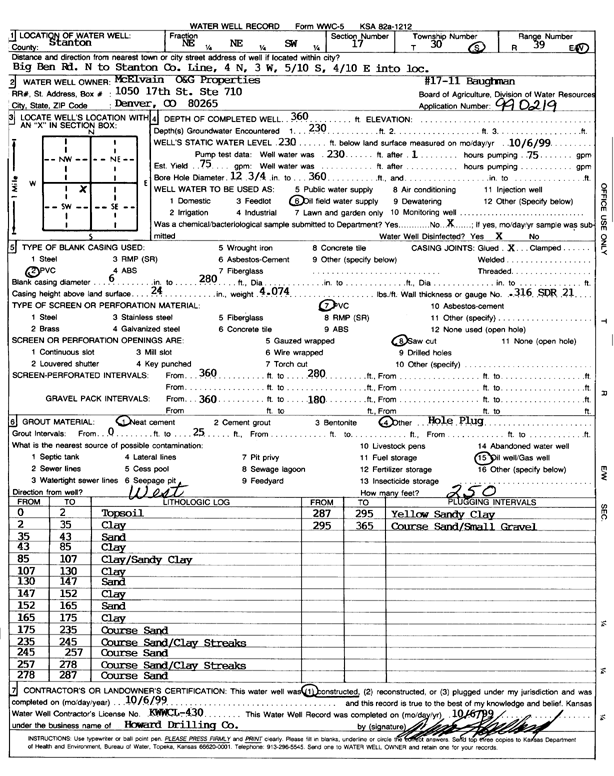
| Owner: McElvain Oil and Gas Properties | Status: Constructed | ||
| Location: T30S, R39W, Sec. 17, ME ME SW | County: Stanton | ||
| Directions: Big Ben Rd N to Stanton Co. Line, 4 mi N, 3 mi W, .5 mi S, .4 mi E into loc | |||
| Latitude: 37.4383619 | Longitude: -101.608637 | Datum NAD 27 | |
| Latitude: 37.4383827 | Longitude: -101.6090819 | Datum NAD 83 | |
| Longitude and latitude calculated by Survey from township-range-section-quarter calls. Only good to within the quarter call accuracy. | |||
| View well on interactive map | |||
| General Info | ||
| Well Depth: 360 ft. | Elevation: ft. | |
| Static Water Level: 230 ft. | Est. Yield: 75 gpm. | |
| Comp. Date: 06-Oct-1999 | Well Use: Oil Field Water Supply | |
| DWR Applic. #: 990219 | Other ID: Baughman 17-11 | |
| Links | |
| No Wizard information available. | |
| View info from WIMAS Water Right Data base... | |
| Driller Info | ||
| Driller: Howard Drilling Company AG, LLC | License #: 430 | |
| Scanned Form | View scan |
|
Chemical Sample Submitted?:
Water Well disinfected?: | ||
| Casing Info | ||
| Casing Type:
Casing Joints: |
Diam: in. to ft | |
| Casing height above land surface: in
Casing Weight: lbs/ft Wall thickness or gauge no.: | ||
| Screen and Perforation Info | ||
| Screen Type: | Screen Openings: | |
| Screen-perforated intervals | From: ft to ft | |
| Gravel pack intervals | From: ft to ft | |
| Grout Info | ||
| Grout used: | From: to ft | |
| Source of Possible Contamination | ||
| Source: | ||
| Direction from well: | Distance: ft | |
| Lithologic Log
(Log data entered by KGS.) | ||
| From: 0 ft. to 2 ft. | topsoil | |
| From: 2 ft. to 35 ft. | clay | |
| From: 35 ft. to 43 ft. | sand | |
| From: 43 ft. to 85 ft. | clay | |
| From: 85 ft. to 107 ft. | clay/sandy clay | |
| From: 107 ft. to 130 ft. | clay | |
| From: 130 ft. to 147 ft. | sand | |
| From: 147 ft. to 152 ft. | clay | |
| From: 152 ft. to 165 ft. | sand | |
| From: 165 ft. to 175 ft. | clay | |
| From: 175 ft. to 235 ft. | coarse sand | |
| From: 235 ft. to 245 ft. | coarse sand/clay streaks | |
| From: 245 ft. to 257 ft. | coarse sand | |
| From: 257 ft. to 278 ft. | coarse sand/clay streaks | |
| From: 278 ft. to 287 ft. | coarse sand | |
| From: 287 ft. to 295 ft. | yellow sandy clay | |
| From: 295 ft. to 365 ft. | coarse sand/small gravel | |