|
|
|
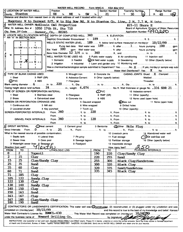
Specific Water Well Detail |
|
|
| Location Info | |||
| Owner: McElvain Oil and Gas Properties | Status: Constructed | ||
| Location: T30S, R40W, Sec. 21, SE NE SW | County: Stanton | ||
| Directions: Hugoton, N to Dermont B/T, W to Big Bow Rd, N to Stanton Co ln, 2 N, 7.7 W | |||
| Latitude: 37.4221083 | Longitude: -101.6995653 | Datum NAD 27 | |
| Latitude: 37.4221288 | Longitude: -101.7000113 | Datum NAD 83 | |
| Longitude and latitude calculated by Survey from township-range-section-quarter calls. Only good to within the quarter call accuracy. | |||
| View well on interactive map | |||
| General Info | ||
| Well Depth: 340 ft. | Elevation: ft. | |
| Static Water Level: 189 ft. | Est. Yield: 100 gpm. | |
| Comp. Date: 22-Oct-1999 | Well Use: Oil Field Water Supply | |
| DWR Applic. #: 990220 | Other ID: Shore E 21-11 | |
| Links | |
| No Wizard information available. | |
| View info from WIMAS Water Right Data base... | |
| Driller Info | ||
| Driller: Howard Drilling Company AG, LLC | License #: 430 | |
| Scanned Form | View scan |
|
Chemical Sample Submitted?:
Water Well disinfected?: | ||
| Casing Info | ||
| Casing Type:
Casing Joints: |
Diam: in. to ft | |
| Casing height above land surface: in
Casing Weight: lbs/ft Wall thickness or gauge no.: | ||
| Screen and Perforation Info | ||
| Screen Type: | Screen Openings: | |
| Screen-perforated intervals | From: ft to ft | |
| Gravel pack intervals | From: ft to ft | |
| Grout Info | ||
| Grout used: | From: to ft | |
| Source of Possible Contamination | ||
| Source: | ||
| Direction from well: | Distance: ft | |
| Lithologic Log
(Log data entered by KGS.) | ||
| From: 0 ft. to 2 ft. | topsoil | |
| From: 2 ft. to 15 ft. | clay | |
| From: 15 ft. to 25 ft. | clay/sandy clay | |
| From: 25 ft. to 35 ft. | sand | |
| From: 35 ft. to 60 ft. | clay | |
| From: 60 ft. to 71 ft. | sand | |
| From: 71 ft. to 105 ft. | clay | |
| From: 105 ft. to 122 ft. | sandy clay | |
| From: 122 ft. to 130 ft. | clay | |
| From: 130 ft. to 140 ft. | sandy clay | |
| From: 140 ft. to 150 ft. | clay | |
| From: 150 ft. to 163 ft. | sand | |
| From: 163 ft. to 167 ft. | clay | |
| From: 167 ft. to 180 ft. | clay/sandy clay | |
| From: 180 ft. to 190 ft. | sand | |
| From: 190 ft. to 220 ft. | clay/sandy clay | |
| From: 220 ft. to 255 ft. | sand | |
| From: 255 ft. to 300 ft. | black clay/sandstone | |
| From: 300 ft. to 320 ft. | black clay | |
| From: 320 ft. to 335 ft. | sand/sandstone | |
| From: 335 ft. to 345 ft. | black clay | |