|
|
|
Specific Water Well Detail |
|
|
| Location Info | |||
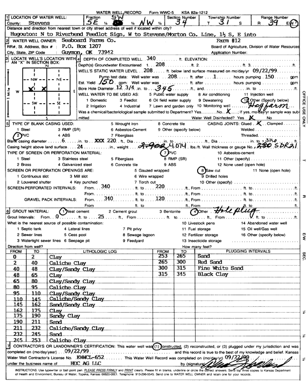
| Owner: Seaboard Farms Co. | Status: Constructed | ||
| Location: T31S, R39W, Sec. 34, SE SW NW | County: Stevens | ||
| Directions: From Hugoton, N to Riverbend Feedlot Sign, W to Stevens/Morton Co Ln, 1.5 S, E | |||
| Latitude: 37.3092572 | Longitude: -101.552467 | Datum NAD 27 | |
| Latitude: 37.3092802 | Longitude: -101.5529063 | Datum NAD 83 | |
| Longitude and latitude calculated by Survey from township-range-section-quarter calls. Only good to within the quarter call accuracy. | |||
| View well on interactive map | |||
| General Info | ||
| Well Depth: 340 ft. | Elevation: ft. | |
| Static Water Level: 208 ft. | Est. Yield: 150 gpm. | |
| Comp. Date: 22-Sep-1999 | Well Use: Feedlot | |
| DWR Applic. #: | Other ID: Farm 12 | |
| Links | |
| No Wizard information available. | |
| View info from WIMAS Water Right Data base... | |
| Driller Info | ||
| Driller: H.D.C. AG, LLC | License #: 652 | |
| Scanned Form | View scan |
|
Chemical Sample Submitted?:
Water Well disinfected?: | ||
| Casing Info | ||
| Casing Type:
Casing Joints: |
Diam: in. to ft | |
| Casing height above land surface: in
Casing Weight: lbs/ft Wall thickness or gauge no.: | ||
| Screen and Perforation Info | ||
| Screen Type: | Screen Openings: | |
| Screen-perforated intervals | From: ft to ft | |
| Gravel pack intervals | From: ft to ft | |
| Grout Info | ||
| Grout used: | From: to ft | |
| Source of Possible Contamination | ||
| Source: | ||
| Direction from well: | Distance: ft | |
| Lithologic Log
(Log data entered by KGS.) | ||
| From: 0 ft. to 2 ft. | clay | |
| From: 2 ft. to 40 ft. | caliche clay | |
| From: 40 ft. to 48 ft. | clay/sandy clay | |
| From: 48 ft. to 65 ft. | clay | |
| From: 65 ft. to 80 ft. | clay/sandy clay | |
| From: 80 ft. to 95 ft. | caliche clay | |
| From: 95 ft. to 110 ft. | clay/sandy clay | |
| From: 110 ft. to 145 ft. | caliche/sandy clay | |
| From: 145 ft. to 162 ft. | sand/sandy clay | |
| From: 162 ft. to 175 ft. | clay | |
| From: 175 ft. to 190 ft. | sandy clay | |
| From: 190 ft. to 211 ft. | sand | |
| From: 211 ft. to 232 ft. | caliche/sandy clay | |
| From: 232 ft. to 245 ft. | sand | |
| From: 245 ft. to 253 ft. | caliche clay | |
| From: 253 ft. to 265 ft. | sand | |
| From: 265 ft. to 300 ft. | red sand | |
| From: 300 ft. to 315 ft. | fine white sand | |
| From: 315 ft. to 345 ft. | black clay | |