|
|
|
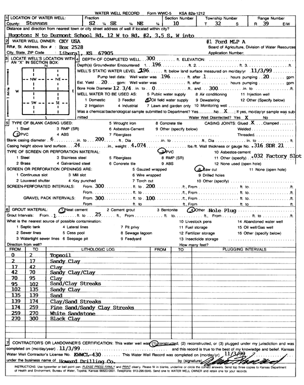
Specific Water Well Detail |
|
|
| Location Info | |||
| Owner: Oxy USA, Inc. | Status: Constructed | ||
| Location: T32S, R39W, Sec. 10, S2 SE NE | County: Stevens | ||
| Directions: Hugoton: N to Dermont School Rd, 12 mi W to Rd #2, 3.5 mi S, W into | |||
| Latitude: 37.2801903 | Longitude: -101.5398885 | Datum NAD 27 | |
| Latitude: 37.2802138 | Longitude: -101.5403263 | Datum NAD 83 | |
| Longitude and latitude calculated by Survey from township-range-section-quarter calls. Only good to within the quarter call accuracy. | |||
| View well on interactive map | |||
| General Info | ||
| Well Depth: 300 ft. | Elevation: ft. | |
| Static Water Level: 296 ft. | Est. Yield: 20 gpm. | |
| Comp. Date: 03-Nov-1999 | Well Use: Oil Field Water Supply | |
| DWR Applic. #: | Other ID: Ford MLP A-1 | |
| Links | |
| No Wizard information available. | |
| View info from WIMAS Water Right Data base... | |
| Driller Info | ||
| Driller: Howard Drilling Company AG, LLC | License #: 430 | |
| Scanned Form | View scan |
|
Chemical Sample Submitted?:
Water Well disinfected?: | ||
| Casing Info | ||
| Casing Type:
Casing Joints: |
Diam: in. to ft | |
| Casing height above land surface: in
Casing Weight: lbs/ft Wall thickness or gauge no.: | ||
| Screen and Perforation Info | ||
| Screen Type: | Screen Openings: | |
| Screen-perforated intervals | From: ft to ft | |
| Gravel pack intervals | From: ft to ft | |
| Grout Info | ||
| Grout used: | From: to ft | |
| Source of Possible Contamination | ||
| Source: | ||
| Direction from well: | Distance: ft | |
| Lithologic Log
(Log data entered by KGS.) | ||
| From: 0 ft. to 2 ft. | topsoil | |
| From: 2 ft. to 17 ft. | sandy clay | |
| From: 17 ft. to 42 ft. | clay | |
| From: 42 ft. to 70 ft. | sandy clay/clay | |
| From: 70 ft. to 95 ft. | clay | |
| From: 95 ft. to 102 ft. | sand/clay streaks | |
| From: 102 ft. to 135 ft. | sandy clay | |
| From: 135 ft. to 139 ft. | sand | |
| From: 139 ft. to 174 ft. | clay/sand streaks | |
| From: 174 ft. to 259 ft. | fine sand/sandy clay streaks | |
| From: 259 ft. to 270 ft. | white sandstone | |
| From: 270 ft. to 300 ft. | black clay | |