|
|
|
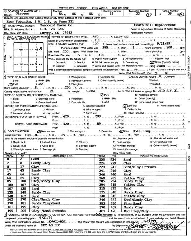
Specific Water Well Detail |
|
|
| Location Info | |||
| Owner: Seaboard Farms Co. | Status: Constructed | ||
| Location: T33S, R39W, Sec. 36, SE NE NE | County: Stevens | ||
| Directions: from Feterita, 1 mi W and 1 mi S to Farm 221 | |||
| Latitude: 37.1382271 | Longitude: -101.5020903 | Datum NAD 27 | |
| Latitude: 37.1382528 | Longitude: -101.5025269 | Datum NAD 83 | |
| Longitude and latitude calculated by Survey from township-range-section-quarter calls. Only good to within the quarter call accuracy. | |||
| View well on interactive map | |||
| General Info | ||
| Well Depth: 420 ft. | Elevation: ft. | |
| Static Water Level: 100 ft. | Est. Yield: 200 gpm. | |
| Comp. Date: 21-Sep-1999 | Well Use: Domestic, Livestock | |
| DWR Applic. #: | Other ID: South Well | |
| Links | |
| No Wizard information available. | |
| View info from WIMAS Water Right Data base... | |
| Driller Info | ||
| Driller: H.D.C. AG, LLC | License #: 652 | |
| Scanned Form | View scan |
|
Chemical Sample Submitted?:
Water Well disinfected?: | ||
| Casing Info | ||
| Casing Type:
Casing Joints: |
Diam: in. to ft | |
| Casing height above land surface: in
Casing Weight: lbs/ft Wall thickness or gauge no.: | ||
| Screen and Perforation Info | ||
| Screen Type: | Screen Openings: | |
| Screen-perforated intervals | From: ft to ft | |
| Gravel pack intervals | From: ft to ft | |
| Grout Info | ||
| Grout used: | From: to ft | |
| Source of Possible Contamination | ||
| Source: | ||
| Direction from well: | Distance: ft | |
| Lithologic Log
(Log data entered by KGS.) | ||
| From: 0 ft. to 2 ft. | sand | |
| From: 2 ft. to 8 ft. | sandy clay | |
| From: 8 ft. to 17 ft. | clay | |
| From: 17 ft. to 45 ft. | sandy clay | |
| From: 45 ft. to 64 ft. | sand | |
| From: 64 ft. to 85 ft. | clay | |
| From: 85 ft. to 100 ft. | clay/sandy clay | |
| From: 100 ft. to 107 ft. | clay | |
| From: 107 ft. to 125 ft. | sand | |
| From: 125 ft. to 148 ft. | sandy clay | |
| From: 148 ft. to 162 ft. | sand | |
| From: 162 ft. to 170 ft. | clay/sandy clay | |
| From: 170 ft. to 181 ft. | sandy clay/sand | |
| From: 181 ft. to 195 ft. | clay | |
| From: 195 ft. to 205 ft. | clay/sand streaks | |
| From: 205 ft. to 224 ft. | sand | |
| From: 224 ft. to 229 ft. | clay | |
| From: 229 ft. to 241 ft. | sand/clay streaks | |
| From: 241 ft. to 246 ft. | clay | |
| From: 246 ft. to 260 ft. | sand | |
| From: 260 ft. to 285 ft. | yellow clay | |
| From: 285 ft. to 294 ft. | sandy clay | |
| From: 294 ft. to 315 ft. | yellow clay | |
| From: 315 ft. to 325 ft. | sand | |
| From: 325 ft. to 340 ft. | sandy clay | |
| From: 340 ft. to 346 ft. | yellow clay | |
| From: 346 ft. to 352 ft. | sand/sandy clay | |
| From: 352 ft. to 370 ft. | fine sand | |
| From: 370 ft. to 407 ft. | sandy clay | |
| From: 407 ft. to 420 ft. | red clay/clay | |