|
|
|
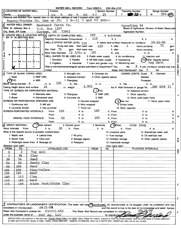
Specific Water Well Detail |
|
|
| Location Info | |||
| Owner: Seaboard Farms Co. | Status: Constructed | ||
| Location: T20S, R38W, Sec. 25, SW SW SW | County: Wichita | ||
| Directions: Kearny/Wichita Co. ln on 25, 1 mi N, 11 mi W and NE into | |||
| Latitude: 38.278884 | Longitude: -101.4736423 | Datum NAD 27 | |
| Latitude: 38.278902 | Longitude: -101.4740857 | Datum NAD 83 | |
| Longitude and latitude calculated by Survey from township-range-section-quarter calls. Only good to within the quarter call accuracy. | |||
| View well on interactive map | |||
| General Info | ||
| Well Depth: 160 ft. | Elevation: ft. | |
| Static Water Level: 110 ft. | Est. Yield: 75 gpm. | |
| Comp. Date: 15-Sep-1999 | Well Use: Feedlot | |
| DWR Applic. #: | Other ID: Spradling 4 | |
| Links | |
| No Wizard information available. | |
| View info from WIMAS Water Right Data base... | |
| Driller Info | ||
| Driller: H.D.C. AG, LLC | License #: 652 | |
| Scanned Form | View scan |
|
Chemical Sample Submitted?:
Water Well disinfected?: | ||
| Casing Info | ||
| Casing Type:
Casing Joints: |
Diam: in. to ft | |
| Casing height above land surface: in
Casing Weight: lbs/ft Wall thickness or gauge no.: | ||
| Screen and Perforation Info | ||
| Screen Type: | Screen Openings: | |
| Screen-perforated intervals | From: ft to ft | |
| Gravel pack intervals | From: ft to ft | |
| Grout Info | ||
| Grout used: | From: to ft | |
| Source of Possible Contamination | ||
| Source: | ||
| Direction from well: | Distance: ft | |
| Lithologic Log
(Log data entered by KGS.) | ||
| From: 0 ft. to 2 ft. | Top soil | |
| From: 2 ft. to 39 ft. | Clay | |
| From: 39 ft. to 56 ft. | Clay | |
| From: 56 ft. to 66 ft. | Sandy clay | |
| From: 66 ft. to 106 ft. | Sand | |
| From: 106 ft. to 109 ft. | Clay, yellow | |
| From: 109 ft. to 140 ft. | Sand | |
| From: 140 ft. to 143 ft. | Clay | |
| From: 143 ft. to 145 ft. | Sand | |
| From: 145 ft. to 160 ft. | White rock and white clay | |