|
|
|
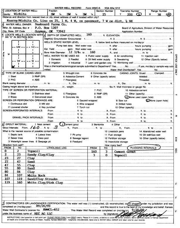
Specific Water Well Detail |
|
|
| Location Info | |||
| Owner: Seaboard Farms Co. | Status: Plugged | ||
| Location: T20S, R38W, Sec. 25, SW SW SW | County: Wichita | ||
| Directions: Kearny/Wichita Co. Ln on 25, 1 N, 4 W on pavement, 7 W on Dirt, .25 NE | |||
| Latitude: 38.278884 | Longitude: -101.4736423 | Datum NAD 27 | |
| Latitude: 38.278902 | Longitude: -101.4740857 | Datum NAD 83 | |
| Longitude and latitude calculated by Survey from township-range-section-quarter calls. Only good to within the quarter call accuracy. | |||
| View well on interactive map | |||
| General Info | ||
| Well Depth: 160 ft. | Elevation: ft. | |
| Static Water Level: ft. | Est. Yield: gpm. | |
| Comp. Date: 20-Sep-1999 | Well Use: (unstated)/abandoned | |
| DWR Applic. #: | Other ID: | |
| Driller Info | ||
| Driller: H.D.C. AG, LLC | License #: 652 | |
| Scanned Form | View scan |
| Casing Info | ||
|
Casing Type:
Diam: in. Casing height above land surface: in | ||
| Grout Info | ||
| Grout used: | From: to ft | |
| Source of Possible Contamination | ||
| Source: | ||
| Direction from well: | Distance: ft | |