|
|
|
Specific Water Well Detail |
|
|
| Location Info | |||
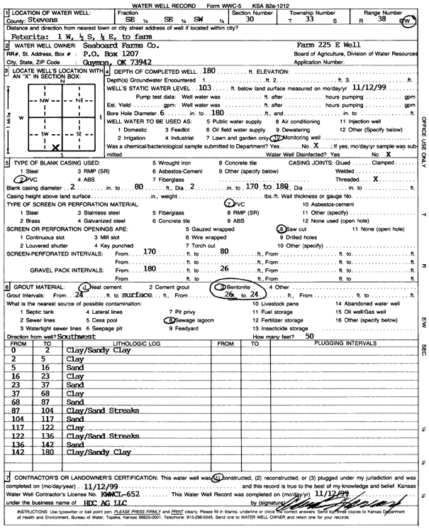
| Owner: Seaboard Farms Co. | Status: Constructed | ||
| Location: T33S, R38W, Sec. 30, SE SE SW | County: Stevens | ||
| Directions: from Feterita, 1 mi W, .5 mi S, .25 mi E to Farm | |||
| Latitude: 37.1418777 | Longitude: -101.4931339 | Datum NAD 27 | |
| Latitude: 37.1419033 | Longitude: -101.4935705 | Datum NAD 83 | |
| Longitude and latitude calculated by Survey from township-range-section-quarter calls. Only good to within the quarter call accuracy. | |||
| View well on interactive map | |||
| General Info | ||
| Well Depth: 180 ft. | Elevation: ft. | |
| Static Water Level: 103 ft. | Est. Yield: gpm. | |
| Comp. Date: 12-Nov-1999 | Well Use: Monitoring well/observation/piezometer | |
| DWR Applic. #: | Other ID: Farm 225 E Well | |
| Driller Info | ||
| Driller: H.D.C. AG, LLC | License #: 652 | |
| Scanned Form | View scan |
|
Chemical Sample Submitted?:
Water Well disinfected?: | ||
| Casing Info | ||
| Casing Type:
Casing Joints: |
Diam: in. to ft | |
| Casing height above land surface: in
Casing Weight: lbs/ft Wall thickness or gauge no.: | ||
| Screen and Perforation Info | ||
| Screen Type: | Screen Openings: | |
| Screen-perforated intervals | From: ft to ft | |
| Gravel pack intervals | From: ft to ft | |
| Grout Info | ||
| Grout used: | From: to ft | |
| Source of Possible Contamination | ||
| Source: | ||
| Direction from well: | Distance: ft | |
| Lithologic Log
(Log data entered by KGS.) | ||
| From: 0 ft. to 2 ft. | clay/sandy clay | |
| From: 2 ft. to 5 ft. | clay | |
| From: 5 ft. to 16 ft. | sand | |
| From: 16 ft. to 23 ft. | clay | |
| From: 23 ft. to 37 ft. | sand | |
| From: 37 ft. to 68 ft. | clay | |
| From: 68 ft. to 87 ft. | sand | |
| From: 87 ft. to 104 ft. | clay/sand streaks | |
| From: 104 ft. to 117 ft. | sand | |
| From: 117 ft. to 122 ft. | clay | |
| From: 122 ft. to 136 ft. | clay/sand streaks | |
| From: 136 ft. to 142 ft. | sand | |
| From: 142 ft. to 180 ft. | clay/sandy clay | |